| Cullivel State Forest | |
|---|---|
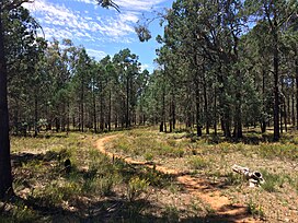
 White cypress pine forest White cypress pine forest | |
| Geography | |
| Location | South Western Slopes, New South Wales, Australia |
| Coordinates | 35°14′19″S 146°24′44″E / 35.23861°S 146.41222°E / -35.23861; 146.41222 |
| Area | 155 ha (1.6 km; 0.6 sq mi) |
| Administration | |
| Governing body | Forestry Corporation of NSW |
| Ecology | |
| Dominant tree species | White cypress pine |
| Lesser flora | Grey box |
Cullivel State Forest is a native forest, located in the South Western Slopes region of New South Wales, in eastern Australia. The 155 ha (380-acre) state forest is located approximately 16 km (9.9 mi) north-east of Urana.
The now-closed section of the Oaklands railway line passes through the northern section of the state forest.
Environment
Cullivel State Forest is dominated by white cypress pine. Other plant species present within the forest include Grey box and Bulloak.
At least three species listed under the Biodiversity Conservation Act 2016 have been recorded within the state forest, including Grey-crowned babbler.
See also
References
- "NSW State Forests" (PDF). Forestry Corporation. 17 March 2014. Archived (PDF) from the original on 5 March 2023. Retrieved 25 March 2023.
- ^ "Regional Forest Assessment: South-western cypress state forests" (PDF). Natural Resources Commission. Archived (PDF) from the original on 14 March 2023. Retrieved 25 March 2023.
- ^ "Urana - Native Vegetation Map ADS-40 Edition 2". Office of Environment & Heritage. February 2012. Archived from the original on 30 October 2022. Retrieved 25 March 2023.
- "Lockhart Shire Council – 2014-15 State of the Environment Report" (PDF). Lockhart Shire. Archived (PDF) from the original on 31 July 2021. Retrieved 25 March 2023.
- "Forests NSW forest management zones - Riverina Region" (PDF). Forestry Corporation of NSW. January 2008. Archived (PDF) from the original on 7 March 2023. Retrieved 25 March 2023.