| Cussewago Creek Tributary to French Creek | |
|---|---|
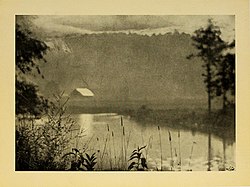
 A 1922 photograph of Cussewago Creek A 1922 photograph of Cussewago Creek | |
  | |
| Location | |
| Country | United States |
| States | Pennsylvania |
| Counties | Crawford Erie |
| Physical characteristics | |
| Source | divide between Cussewago Creek and Elk Creek |
| • location | about 0.25 miles north of Eureka Corners, Pennsylvania |
| • coordinates | 41°54′33″N 080°12′08″W / 41.90917°N 80.20222°W / 41.90917; -80.20222 |
| • elevation | 1,315 ft (401 m) |
| Mouth | French Creek |
| • location | Meadville, Pennsylvania |
| • coordinates | 41°38′21″N 080°09′44″W / 41.63917°N 80.16222°W / 41.63917; -80.16222 |
| • elevation | 1,063 ft (324 m) |
| Length | 35.08 mi (56.46 km) |
| Basin size | 97.29 square miles (252.0 km) |
| Discharge | |
| • location | French Creek |
| • average | 166.02 cu ft/s (4.701 m/s) at mouth with French Creek |
| Basin features | |
| Progression | south |
| River system | Allegheny River |
| Tributaries | |
| • left | Spring Run |
| • right | West Branch Cussewago Creek Carr Run |
| Bridges | I-86, Hazen Road, North Road, Findley Lake Road, Greenman Road, I-86, Station Road, Ashton Road, NY 89, Wildman Road, Knoyle Road, Jones Road, PA 89, |
Cussewago Creek is a 35.08 mi (56.46 km) long tributary to French Creek that is classed as a 4th order stream on the EPA waters geoviewer site.
Variant names
According to the Geographic Names Information System, it has also been known historically as:
- Cassewago Creek
- Kossewago Creek
The name of the creek is alleged to come from the aboriginal inhabitants, and is said to mean, "big belly".
Course
Cussewago Creek rises north of Eureka Springs in Erie County, Pennsylvania and flows south into Crawford County, Pennsylvania to meet French Creek at Meadville.
Watershed
Cussewago Creek drains 97.29 square miles (252.0 km) of Erie Drift Plain (glacial geology). The watershed receives an average of 45.4 in/year of precipitation and has a wetness index of 492.71. The watershed is about 44% forested.
Natural History
Cussewago Creek supports a diverse fauna, including mammals, amphibians, fishes, and mollusks.
See also
References
- ^ "GNIS Detail - Cussewago Creek". geonames.usgs.gov. US Geological Survey. Retrieved 22 September 2019.
- ^ "Cussewago Creek Topo Map, Crawford County PA (Meadville Area)". TopoZone. Locality, LLC. Retrieved 22 September 2019.
- ^ "ArcGIS Web Application". epa.maps.arcgis.com. US EPA. Retrieved 22 September 2019.
- ^ "Cussewago Creek Watershed Report". Waters Geoviewer. US EPA. Retrieved 22 September 2019.
- http://history.rays-place.com/pa/cussewago-pa.htm
- "Archived copy" (PDF). pa.audubon.org. Archived from the original (PDF) on 1 April 2012. Retrieved 14 January 2022.
{{cite web}}: CS1 maint: archived copy as title (link)