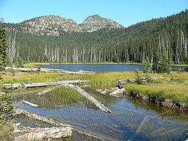
| Dagger Lake | |
|---|---|
 Dagger Lake Dagger Lake | |
  | |
| Location | North Cascades National Park, Chelan County, Washington, United States |
| Coordinates | 48°28′05″N 120°39′18″W / 48.46806°N 120.65500°W / 48.46806; -120.65500 |
| Lake type | Glacial Lake |
| Primary outflows | East Fork Bridge Creek |
| Basin countries | United States |
| Max. length | 300 yd (270 m) |
| Max. width | 150 yd (140 m) |
| Surface elevation | 5,512 ft (1,680 m) |
Dagger Lake is located in North Cascades National Park, in the U. S. state of Washington. Dagger Lake is accessible via the Twisp Pass Trail and the lake is 7.6 mi (12.2 km) from the North Cascades Highway or 4.7 mi (7.6 km) from the Twisp River Road trailhead in Wenatchee National Forest.

References
- ^ "Dagger Lake". Geographic Names Information System. United States Geological Survey, United States Department of the Interior. Retrieved June 8, 2013.
- McAlester Mountain, WA (Map). Topoquest (USGS Quads). Retrieved June 8, 2013.
- "Twisp Pass (Dagger Lake) Trail". Backpacking. National Park Service. Retrieved June 9, 2013.
This Chelan County, Washington state location article is a stub. You can help Misplaced Pages by expanding it. |