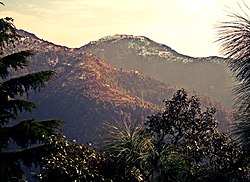
Hill Station in Himachal Pradesh, India
| Dalhousie ḍalhauzī | |
|---|---|
| Hill Station | |
 Hill Station of Dalhousie in Chamba district, Himachal Pradesh, India Hill Station of Dalhousie in Chamba district, Himachal Pradesh, India | |
  | |
| Coordinates: 32°32′N 75°59′E / 32.53°N 75.98°E / 32.53; 75.98 | |
| Country | |
| State | |
| District | Chamba |
| Named for | Earl of Dalhousie |
| Elevation | 1,970 m (6,460 ft) |
| Population | |
| • Total | 7,051 |
| • Rank | 25 in HP |
| Time zone | UTC+5:30 (IST) |
| PIN | 176304 |
| Telephone code | +91 1899 |
| Vehicle registration | HP-47 |
Dalhousie (Hindi pronunciation: [ɖəlɦɔːziː]) is a hill station, near town of Chamba in Chamba district in the Indian state of Himachal Pradesh. It is situated on five hills and has an elevation of 1,970 m (6,460 ft) above sea level.
Etymology
Dalhousie Town was named after The Earl of Dalhousie, who was the British Governor-General in India while establishing this place as a summer retreat.
Climate
Dalhousie has a humid subtropical climate. Late summer and early spring see torrential rainfall due to monsoonal influence. The city sees over 90 frost days per year and 20-30 snowy days. The average night temperature during the season is around 4 °C (39 °F), while the maximum is close to 11 °C (52 °F).
| Climate data for Dalhousie, India (1961–1990, rainfall 1951–2000) | |||||||||||||
|---|---|---|---|---|---|---|---|---|---|---|---|---|---|
| Month | Jan | Feb | Mar | Apr | May | Jun | Jul | Aug | Sep | Oct | Nov | Dec | Year |
| Record high °C (°F) | 21.7 (71.1) |
29.4 (84.9) |
30.7 (87.3) |
32.6 (90.7) |
34.4 (93.9) |
35.5 (95.9) |
32.8 (91.0) |
28.4 (83.1) |
28.0 (82.4) |
27.9 (82.2) |
25.7 (78.3) |
23.9 (75.0) |
35.5 (95.9) |
| Mean daily maximum °C (°F) | 11.5 (52.7) |
12.7 (54.9) |
17.3 (63.1) |
21.3 (70.3) |
24.9 (76.8) |
26.6 (79.9) |
23.6 (74.5) |
22.7 (72.9) |
22.8 (73.0) |
22.0 (71.6) |
17.8 (64.0) |
14.4 (57.9) |
19.8 (67.6) |
| Mean daily minimum °C (°F) | 2.3 (36.1) |
2.7 (36.9) |
6.3 (43.3) |
10.5 (50.9) |
13.8 (56.8) |
16.2 (61.2) |
15.7 (60.3) |
15.5 (59.9) |
13.9 (57.0) |
10.9 (51.6) |
6.9 (44.4) |
4.4 (39.9) |
9.9 (49.8) |
| Record low °C (°F) | −8.6 (16.5) |
−8.0 (17.6) |
−1.2 (29.8) |
0.6 (33.1) |
2.0 (35.6) |
8.0 (46.4) |
8.3 (46.9) |
11.1 (52.0) |
8.0 (46.4) |
−2.2 (28.0) |
0.1 (32.2) |
−8.0 (17.6) |
−8.6 (16.5) |
| Average rainfall mm (inches) | 155.1 (6.11) |
122.2 (4.81) |
155.7 (6.13) |
96.2 (3.79) |
62.5 (2.46) |
130.8 (5.15) |
588.0 (23.15) |
573.2 (22.57) |
245.7 (9.67) |
73.0 (2.87) |
37.7 (1.48) |
70.9 (2.79) |
2,311 (90.98) |
| Average rainy days (≥ 2.5 mm) | 6.5 | 5.9 | 6.5 | 5.3 | 4.2 | 6.4 | 18.3 | 19.8 | 8.8 | 2.7 | 1.8 | 3.4 | 89.6 |
| Average relative humidity (%) (at 17:30 IST) | 72 | 67 | 64 | 57 | 50 | 54 | 78 | 85 | 79 | 70 | 70 | 68 | 68 |
| Source: India Meteorological Department | |||||||||||||
See also
- Lootera, 2013 film shot in Dalhousie
- Almost Pyaar with DJ Mohabbat, 2023 film shot in Dalhousie
References
- Gopal, Madan (1990). K.S. Gautam (ed.). India through the ages. Publication Division, Ministry of Information and Broadcasting, Government of India. p. 177.
- "Dalhousie: perfect summer getaway". Bangalore Mirror. 4 March 2010. Archived from the original on 6 March 2010. Retrieved 1 May 2013.
- "Climate of Himachal Pradesh" (PDF). Climatological Summaries of States Series - No. 15. India Meteorological Department. January 2010. pp. 36–42. Archived from the original (PDF) on 20 February 2020. Retrieved 8 March 2020.
- "Snowfall throws shooting schedule of Lootera out of gear".
External links
 Dalhousie, India travel guide from Wikivoyage
- More information about Dalhousie.
| State of Himachal Pradesh | |||||||
|---|---|---|---|---|---|---|---|
| Capital: Shimla | |||||||
| Topics | |||||||
| History | |||||||
| Culture | |||||||
| Jurisdiction | |||||||
| Districts and divisions |
| ||||||
| Major cities | |||||||
| Economy | |||||||
| Geography | |||||||
| Images and others | |||||||