Protected area in New South Wales, Australia
| Dalrymple-Hay Nature Reserve New South Wales | |
|---|---|
| IUCN category Ia (strict nature reserve) | |
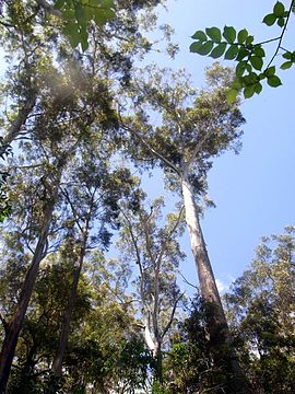
 Blackbutt at located in the reserve Blackbutt at located in the reserve | |
 | |
| Nearest town or city | St Ives |
| Coordinates | 33°44′12″S 151°9′15″E / 33.73667°S 151.15417°E / -33.73667; 151.15417 |
| Established | January 1972 (1972-01) |
| Area | 0.11 km (0.0 sq mi) |
| Managing authorities | NSW National Parks and Wildlife Service |
| Website | Dalrymple-Hay Nature Reserve |
| See also | Protected areas of New South Wales |
The Dalrymple-Hay Nature Reserve is a protected nature reserve that is located in the northerns suburbs of Sydney, New South Wales, Australia. The 10.768-hectare (26.61-acre) reserve is situated in the suburb of St Ives, 15 kilometres (9.3 mi) from the Sydney central business district.
The reserve is the most significant remnant of the eucalyptus Blue Gum High Forest which dominated much of the shale based forests north of Sydney. Only 1% of the original forest remains. The reserve is a traditional part of the Aboriginal country, which stretched to the northern shores of Sydney Harbor to Broken Bay in the north.
Features
Average annual rainfall is a relatively high 1,400 millimetres (55 in).
Bush regeneration programs have been implemented for many years. Invasive weeds such as privet, large leave privet, trad, lantana and camphor laurel continue to be troublesome.
Richard Dalrymple-Hay, proposed that this forest area should be preserved, in the 1920s. The area was originally part of the hunting grounds of the Kuringgai people. Dalrymple-Hay Nature Reserve is listed on the Register of the National Estate.
Flora
180 native plants have been found in this reserve. Blackbutt is the dominant canopy species, other trees occurring include Sydney blue gum, grey ironbark, turpentine and rusty gum. Many of the blackbutt are in excess of 40 metres (130 ft) tall. Interesting smaller plants include false bracken, orange bark, downy chance and muttonwood.
Fauna
Ringtail possums, sugar gliders, brushtail possums and grey-headed flying foxes are common. There are occasional sightings of wallabies. Birds such as rainbow lorikeets, Australian king parrots, crimson rosellas, currawongs, variegated wrens, black-faced cuckoo-shrikes, superb fairy wrens and silvereyes are some of the many birds found here.
See also
References
- ^ "Dalrymple-Hay Nature Reserve: Park management". Office of Environment and Heritage. Government of New South Wales. Retrieved 19 September 2014.
- "Dalrymple-Hay Nature Reserve: Plan of management" (PDF). NSW National Parks and Wildlife Service (PDF). Government of New South Wales. May 2004. ISBN 0-7313-6638-7. Retrieved 19 September 2014.
- "Dalrymple-Hay Nature Reserve | Learn more". NSW National Parks. Retrieved 1 September 2021.
- The Heritage of Australia, Macmillan Company, 1981, p.2/33
- National Parks & Wildlife Service, info from a Field Officer
| Nature reserves of New South Wales, Australia | |
|---|---|
| Central West & Orana |
|
| Far West |
|
| Hunter & Central Coast |
|
| Illawarra-Shoalhaven |
|
| New England-North West |
|
| North Coast |
|
| Riverina-Murray |
|
| Southeast & Tablelands |
|
| Sydney & Surrounds |
|
| Protected areas of New South Wales | |
This article related to the geography of Sydney is a stub. You can help Misplaced Pages by expanding it. |
This New South Wales protected areas related article is a stub. You can help Misplaced Pages by expanding it. |