Hamlet in England
| Dalton | |
|---|---|
| Hamlet | |
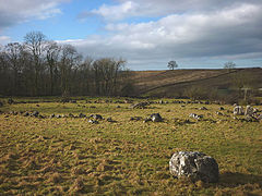
 Russell Farm Enclosure, Dalton Russell Farm Enclosure, Dalton | |
  | |
| OS grid reference | SD542766 |
| Civil parish | |
| Unitary authority | |
| Ceremonial county | |
| Region | |
| Country | England |
| Sovereign state | United Kingdom |
| Post town | CARNFORTH |
| Postcode district | LA6 |
| Dialling code | 01524 |
| Police | Cumbria |
| Fire | Cumbria |
| Ambulance | North West |
| UK Parliament | |
| 54°10′59″N 2°42′04″W / 54.183°N 2.701°W / 54.183; -2.701 | |
Dalton is a hamlet and former civil parish, now in the parish of Burton-in-Kendal, in the Westmorland and Furness district, Cumbria, England. Until 1894 it was in Lancashire, but was transferred to Westmorland "in accordance with the unanimous desire of the inhabitants". In 1961 the parish had a population of 99. Dalton was formerly a township in Burton-in-Kendal parish, from 1866 Dalton was a civil parish in its own right until it was abolished on 1 April 1986 and merged with Burton to form "Burton-in-Kendal".
Dalton is located about a mile east of Burton-in-Kendal and gives its name to Dalton Crags and Dalton Hall.
Remains of medieval settlements in the area have been recorded by archaeologists, and "Dalton medieval village and parts of its associated medieval open field system centred 620m ENE of Dalton Hall" is listed as a scheduled monument.
Dalton Old Hall farmhouse is a grade II listed building.
References
- "The parish of Burton in Kendal: Dalton". Victoria County History: Lancashire: Vol 8. 1914. pp. 183–185. Retrieved 17 September 2018.
- "Population statistics Dalton CP/Tn through time". A Vision of Britain through Time. Retrieved 31 December 2021.
- "History of Dalton, in South Lakeland and Westmorland". A Vision of Britain through Time. Retrieved 31 December 2021.
- "Relationships and changes Dalton CP/Tn through time". A Vision of Britain through Time. Retrieved 31 December 2021.
- "The South Lakeland (Parishes) Order 1985" (PDF). Local Government Boundary Commission for England. Archived from the original (PDF) on 31 December 2021. Retrieved 31 December 2021.
- Newman, Caron; Newman, Richard (2009). "The Evolution of Dalton, near Kendal, Cumbria: preliminary results" (PDF). Medieval Settlement Research. 24: 6–13. Retrieved 17 September 2018.
- Historic England. "Dalton medieval village and parts of its associated medieval open field system centred 620m ENE of Dalton Hall (1021249)". National Heritage List for England. Retrieved 17 September 2018.
- Historic England. "Dalton Old Hall Farmhouse (1204670)". National Heritage List for England. Retrieved 17 September 2018.
External links
- Map sources for Dalton, Cumbria
- Cumbria County History Trust: Dalton (nb: provisional research only – see Talk page)
- Dalton: historical and genealogical information at GENUKI.
This Cumbria location article is a stub. You can help Misplaced Pages by expanding it. |