| This article needs additional citations for verification. Please help improve this article by adding citations to reliable sources. Unsourced material may be challenged and removed. Find sources: "Tamsui River" – news · newspapers · books · scholar · JSTOR (December 2008) (Learn how and when to remove this message) |
| Tamsui River | |
|---|---|
 The mouth of Tamsui River The mouth of Tamsui River | |
| Native name | 淡水河 (Chinese) |
| Location | |
| Country | Taiwan |
| Physical characteristics | |
| Source | |
| • location | Pintian Mountain |
| • elevation | 3,529 metres (11,578 ft) |
| Mouth | |
| • location | Taiwan Strait |
| • elevation | 0 metres (0 ft) |
| Length | 158.7 kilometres (98.6 mi) |
| Basin size | 2,726 square kilometres (1,053 sq mi) |
| Discharge | |
| • average | 210 cubic metres per second (7,400 cu ft/s) |
| • maximum | 13,600 m/s (480,000 cu ft/s) |
The Tamsui River (alternatively Danshui River, Chinese: 淡水河; pinyin: Dànshǔi Hé; Wade–Giles: Tan-shui Ho; Pe̍h-ōe-jī: Tām-chúi-hô; lit. 'Freshwater River') is third longest river in Taiwan after Zhuoshui River and Gaoping River, with a total length of 158.7 km (98.6 mi), flowing through Hsinchu County, Taoyuan, Taipei and New Taipei City. It is located in northern part of the island.
Geography


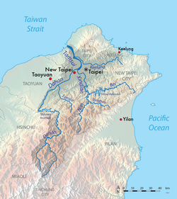
The Tamsui River begins at the confluence of Xindian River and Dahan River at the western boundary of Taipei and New Taipei City, just north of Banqiao District, and flows northward and northwestward, passing the eponymous Tamsui District, then emptying into the Taiwan Strait.
The river's three tributaries are the Xindian River, Dahan River and Keelung River. The Dahan River is the main tributary and has its headwaters in the Pintian Mountain in Hsinchu County and flows through Hsinchu County, Taoyuan City and New Taipei City. As a river system including the Dahan River, the Tamsui River has a total length of 159 km (99 mi) and a drainage area of 2,726 km (1,053 sq mi).
A major artificial distributary on the left bank of the Tamsui, the Erchong Floodway, was completed in 1984 as part of a flood control scheme for the Taipei Basin. The flood control plan for Greater Taipei dated back to 1959, and by 1987, dykes had been built along the banks of the Tamsui.
Pollution

The Tamsui River is heavily polluted by both raw sewage and industrial pollution from illegal industry. Clean up and natural river restoration is on the agenda of the Taipei City Government, Executive Yuan and several citizen organizations. Through the 1970s, the river was clean and could support ship traffic and fishing. By the 1980s, the Tamsui was polluted and was dominated by tilapia. Governmental efforts to clean up the Tamsui include "The Recovery Project of the Tamsui River Watershed Area" implemented in 1987 by the Environmental Protection Administration, at the time a division of the Department of Health. This effort was finally undertaken as a result of massive public pressure. The first goal set was to have the river no longer smell in the summer. Water quality improved significantly however efforts to improve water quality were hampered by the numerous residences whose sewage emptied straight into the river. Cleanup efforts continue to the present day, and include linking the watershed's residents to a shared sewer system.
Fauna
Scientists conducting research on what they believed to be Meretrix lusoria in the Tamsui River sent samples for genetic analysis and discovered that they were a distinct species: Meretrix taiwanica.
Popular culture
Due to its pollution the phrase “I’d rather jump into the Tamsui River!” was once a popular saying in Taipei.
Bridges
Several famous bridges run across the river, from south to north downstream:
- Zhongxing Bridge [zh]
- Zhongxiao Bridge [zh]
- Taipei Bridge
- Danshui River Bridge [zh]
- Chongyang Bridge [zh]
- Guandu Bridge
- Danjiang Bridge (under construction)
- Tamsui Lover's Bridge (incomplete crossing within Tamsui only)
See also
References
- "Chapter 1: Geography & Demographics". The Republic of China Yearbook 2014 (PDF). Executive Yuan, R.O.C. 2014. p. 44. ISBN 9789860423020.
- "Is it all the fault of "straightening"?". Taiwan Panorama. December 1987. Retrieved 19 March 2022.
- Taipei from the River - Marco Casagrande, E-Architect March, 2011
- Tamshui River Restoration Project Commercial, Taipei City Government, retrieved November 29, 2012.
- Chang, Jack (June 1987). "A walk along the bank". Taiwan Panorama. Retrieved 19 March 2022.
- "Reclaiming The Tamsui River". Free China Review. Retrieved 19 March 2022.
- ^ "Diagnosing the Tamsui". Taiwan Panorama. June 1987.
- Chang, Ching-ju (December 1991). ""A fierce dragon" can cross the river after all–exotics are driving out Taiwan's native species". Taiwan Panorama. Retrieved 19 March 2022.
- Chang, Gypsy (June 1987). "It's not just cleaning up a sewer..." Taiwan Panorama. Retrieved 19 March 2022.
- ^ Cheung, Han. "Taiwan in Time: Tamsui River on life support". taipeitimes.com. Taipei Times. Retrieved 22 April 2022.
- Han Cheung (20 March 2022). "Taiwan in Time: Tamsui River on life support". Taipei Times. Retrieved 20 March 2022.
- PFLUGHOEFT, ASPEN. "New species was hiding in plain sight and being raised on Taiwanese farms, experts say". miamiherald.com. Miami Herald. Retrieved 13 April 2023.
- "Second phase of new Danjiang Bridge over Tamsui River begin". China Post. Retrieved 25 May 2020.
Notes
- For images, see Danshui River Bridge.
25°10′30″N 121°24′30″E / 25.175°N 121.408333333°E / 25.175; 121.408333333
Categories: