| Davenport Murchison Ranges Northern Territory | |||||||||||||||
|---|---|---|---|---|---|---|---|---|---|---|---|---|---|---|---|
 Old Police Station Waterhole in Iytwelepenty / Davenport Range National Park Old Police Station Waterhole in Iytwelepenty / Davenport Range National Park | |||||||||||||||
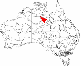
 The interim Australian bioregions, The interim Australian bioregions,with Davenport Murchison Ranges in red | |||||||||||||||
| Area | 58,051.08 km (22,413.6 sq mi) | ||||||||||||||
| |||||||||||||||
Davenport Murchison Ranges is an interim Australian bioregion located in the Northern Territory. It has an area of 5,805,108 hectares (14,344,730 acres). The bioregion is part of the larger Great Sandy-Tanami desert ecoregion.
Subregions
Davenport Murchison Ranges is made up of three subregions:
- Ashburton Range (DMR01) – 1,218,621 hectares (3,011,280 acres)
- Davenport (DMR02) – 1,589,590 hectares (3,928,000 acres)
- Barkly (DMR03) – 2,996,897 hectares (7,405,490 acres)
Protected areas
Less than 5% of the bioregion is in protected areas, the largest of which is Iytwelepenty / Davenport Range National Park in the Barkly subregion.
References
- Environment Australia. "Revision of the Interim Biogeographic Regionalisation for Australia (IBRA) and Development of Version 5.1 – Summary Report" (PDF). Department of the Environment and Water Resources, Australian Government. Retrieved 3 May 2022.
{{cite journal}}: Cite journal requires|journal=(help) - ^ "Interim Biogeographic Regionalisation for Australia (IBRA7) regions and codes". Department of Sustainability, Environment, Water, Population and Communities. Commonwealth of Australia. 2012. Retrieved 3 May 2022.
- "National Reserve System - IBRA Region Protection Level" (PDF). Department of Agriculture, Water and the Environment, Australian Government. Geospatial & Information Analytics Branch, Australian Government Department of Agriculture, Water and the Environment. Commonwealth of Australia. March 2021. Retrieved 28 May 2022.