| Dieng Volcanic Complex | |
|---|---|
 | |
| Highest point | |
| Elevation | 2,565 m (8,415 ft) |
| Coordinates | 7°12′S 109°55′E / 7.20°S 109.92°E / -7.20; 109.92 |
| Geography | |
  | |
| Geology | |
| Mountain type | Complex volcano |
| Last eruption | April 2021 |
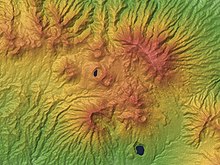
The Dieng Volcanic Complex (Javanese: ꦢꦶꦲꦾꦁ, romanized: Dihyang) is a volcanic complex located on the Dieng Plateau in Central Java, Indonesia, a complex of volcanoes. The volcanic complex consists of two or more stratovolcanoes, more than 20 small craters, and Pleistocene to Holocene-age volcanic cones. It covers a 6 by 14 kilometres (3.7 by 8.7 mi) area. The Prahu stratovolcano was truncated by a large Pleistocene caldera and then filled by parasitic cones, lava domes, and craters which is 120 °C (248 °F). Some of them are turned into lakes. Toxic volcanic gas has caused fatalities and is a hazard at several craters. On 20 February 1979, 149 people died of gas poisoning in Pekisaran Village on the plateau near the Sinila Crater. The area is also home to a major geothermal project.

See also
References
- ^ "Dieng Volcanic Complex". Global Volcanism Program. Smithsonian Institution.
- Fumerole death blamed on poor signs' Archived 2016-03-04 at the Wayback Machine, The Jakarta Post
External links
- Articles about the Dieng Plateau
This Central Java location article is a stub. You can help Misplaced Pages by expanding it. |