Unincorporated community in Indiana, United States
| Dodds Bridge, Indiana | |
|---|---|
| Unincorporated community | |
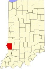
 Sullivan County's location in Indiana Sullivan County's location in Indiana | |
 | |
| Coordinates: 39°09′26″N 87°31′26″W / 39.15722°N 87.52389°W / 39.15722; -87.52389 | |
| Country | United States |
| State | Indiana |
| County | Sullivan |
| Township | Turman |
| Elevation | 463 ft (141 m) |
| Time zone | UTC-5 (Eastern (EST)) |
| • Summer (DST) | UTC-4 (EDT) |
| ZIP code | 47879 |
| Area code(s) | 812, 930 |
| GNIS feature ID | 433595 |
Dodds Bridge is an unincorporated community in Turman Township, Sullivan County, in the U.S. state of Indiana.
The community is part of the Terre Haute Metropolitan Statistical Area.
Geography
Dodds Bridge is located at 39°09′26″N 87°31′26″W / 39.15722°N 87.52389°W / 39.15722; -87.52389.
References
- "US Board on Geographic Names". United States Geological Survey. October 25, 2007. Retrieved August 30, 2016.
- "Dodds Bridge, Indiana". Geographic Names Information System. United States Geological Survey. Retrieved August 5, 2017.
| Municipalities and communities of Sullivan County, Indiana, United States | ||
|---|---|---|
| County seat: Sullivan | ||
| Cities | ||
| Towns | ||
| Townships | ||
| CDPs | ||
| Other communities | ||
| Ghost towns | ||
| Footnotes | ‡This populated place also has portions in an adjacent county or counties | |
This Sullivan County, Indiana location article is a stub. You can help Misplaced Pages by expanding it. |
