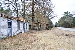
Ghost town in Mississippi, United States
| Dogtown, Mississippi | |
|---|---|
| Ghost town | |
 | |
  | |
| Coordinates: 34°15′53″N 89°17′09″W / 34.26472°N 89.28583°W / 34.26472; -89.28583 | |
| Country | United States |
| State | Mississippi |
| County | Lafayette |
| Elevation | 423 ft (129 m) |
| Time zone | UTC-6 (Central (CST)) |
| • Summer (DST) | UTC-5 (CDT) |
| Area code | 662 |
| GNIS feature ID | 693095 |
Dogtown is a ghost town in Lafayette County, Mississippi, United States, located on Highway 334, 17.6 miles (28.3 km) southeast of Oxford. At one time it was the location of Dogtown School.
All that remains of Dogtown is the abandoned White's Grocery.
References
- "Dogtown". Geographic Names Information System. United States Geological Survey, United States Department of the Interior.
- "Dogtown School (historical)". Geographic Names Information System. United States Geological Survey, United States Department of the Interior.
- "The Places I Live: Mississippi". Betty Press. Retrieved October 11, 2016.
| Municipalities and communities of Lafayette County, Mississippi, United States | ||
|---|---|---|
| County seat: Oxford | ||
| City |  | |
| Towns | ||
| CDPs | ||
| Other communities | ||
| Ghost town | ||
This Lafayette County, Mississippi state location article is a stub. You can help Misplaced Pages by expanding it. |