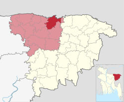
| Dowarabazar দোয়ারাবাজার | |
|---|---|
| Upazila | |
| Nickname: Duarabazar | |
 | |
| Country | |
| Division | Sylhet |
| District | Sunamganj |
| Established | 1976 |
| Government | |
| • MP (Sunamganj-5) | MR. Muhibur Rahman Manik (Awami League) |
| Area | |
| • Total | 263.35 km (101.68 sq mi) |
| Population | |
| • Total | 260,513 |
| • Density | 990/km (2,600/sq mi) |
| Demonym(s) | Dowarabazari, Duarabazari |
| Time zone | UTC+6 (BST) |
| Postal code | 3070 |
| Website | www |
Dowarabazar (Bengali: দোয়ারাবাজার, is an upazila of Sunamganj District in the Division of Sylhet, Bangladesh.
Geography
Dowarabazar is located at 25°03′00″N 91°34′00″E / 25.0500°N 91.5667°E / 25.0500; 91.5667. It has 42,693 households and total area 263.35 km and bounded by the Indian state of Meghalaya and border on the north, and Chhatak Upazila on the south and east, Sunamganj Sadar Upazila on the west. Main rivers are Surma, Jadukata etc.
Demographics
| Religions in Dowarabazar Upazila (2022) | ||||
|---|---|---|---|---|
| Religion | Percent | |||
| Islam | 95.80% | |||
| Hinduism | 4.11% | |||
| Other or not stated | 0.09% | |||
According to the 2011 Census of Bangladesh, Dowarabazar Upazila had 42,693 households and a population of 228,460. 72,682 (31.81%) were under 10 years of age. Dowarabazar had a literacy rate (age 7 and over) of 30.38%, compared to the national average of 51.8%, and a sex ratio of 1035 females per 1000 males. 14,794 (6.48%) lived in urban areas.
Administration
Dowarabazar Upazila is divided into nine union parishads: Bangla Bazar, Bouglabazar, Dohalia, Dowarabazar, Laxmipur, Mannargaon, Norsingpur, Pandargaon, and Surma. The union parishads are subdivided into 151 mauzas and 308 villages.
Dowarabazar Model Govt Primary School, Dowarabazar High School and Dowarabazar Degree College is situated in Dowarabazar town.
Notable residents
- Dewan Mohammad Azraf, teacher, author, politician, journalist and philosopher
- Abdul Mazid, freedom fighter, Member of Bangladesh Parliament
- Kakon Bibi, Bangladeshi freedom fighter, Bir Protik
See also
References
- National Report (PDF). Population and Housing Census 2022. Vol. 1. Dhaka: Bangladesh Bureau of Statistics. November 2023. p. 404. ISBN 978-9844752016.
- "Bangladesh Postal Code". Dhaka: Bangladesh Postal Department under the Department of Posts and Telecommunications of the Ministry of Posts, Telecommunications and Information Technology of the People's Republic of Bangladesh. 20 October 2024.
- Jayanta Singh Roy (2012). "Dowarabazar Upazila". In Sirajul Islam; Miah, Sajahan; Khanam, Mahfuza; Ahmed, Sabbir (eds.). Banglapedia: the National Encyclopedia of Bangladesh (Online ed.). Dhaka, Bangladesh: Banglapedia Trust, Asiatic Society of Bangladesh. ISBN 984-32-0576-6. OCLC 52727562. OL 30677644M. Retrieved 6 January 2025.
- Population and Housing Census 2022 - District Report: Sunamganj (PDF). District Series. Dhaka: Bangladesh Bureau of Statistics. June 2024. ISBN 978-984-475-222-1.
- ^ "Bangladesh Population and Housing Census 2011 Zila Report – Sunamganj" (PDF). bbs.gov.bd. Bangladesh Bureau of Statistics.
- "Community Tables: Sunamganj district" (PDF). bbs.gov.bd. Bangladesh Bureau of Statistics. 2011.
| Sunamganj District | ||
|---|---|---|
| Capital: Sunamganj | ||
| Upazilas | ||
| Constituencies | ||
| Attractions and sites | ||
| Rivers | ||
| Inhabited areas | ||
| Educational institutions | ||
| Transport | ||
| History | ||
| Capital: Sylhet | ||
| Habiganj District |  | |
| Moulvibazar District | ||
| Sunamganj District | ||
| Sylhet District | ||
This Sylhet Division location article is a stub. You can help Misplaced Pages by expanding it. |