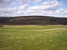
Droop Hill, Aberdeenshire. Courtesy: Dominic Dawn Harry and Jacob Paterson Droop Hill is a mountain landform in the Kincardine and Mearns region of Aberdeenshire , Scotland . The locale had been featured in a windfarm proposal submitted to the Aberdeenshire Council .
See also
References
Northeast gentle slopes of Droop Hill. Courtesy: C.Michael Hogan United Kingdom Ordnance Survey Map Landranger 45, Stonehaven and Banchory, 1:50,000 scale, 2004
Droop Hill wind farm proposal (2006) APP/2006/3278, Aberdeenshire Council Line notes
56°55′27″N 2°24′09″W / 56.9241°N 2.4026°W / 56.9241; -2.4026
Categories :
Text is available under the Creative Commons Attribution-ShareAlike License. Additional terms may apply.
**DISCLAIMER** We are not affiliated with Wikipedia, and Cloudflare.
The information presented on this site is for general informational purposes only and does not constitute medical advice.
You should always have a personal consultation with a healthcare professional before making changes to your diet, medication, or exercise routine.
AI helps with the correspondence in our chat.
We participate in an affiliate program. If you buy something through a link, we may earn a commission 💕
↑

