Village in Leinster, Ireland
| Dysart An Díseart | |
|---|---|
| Village | |
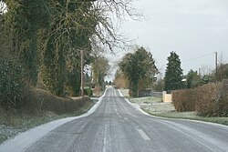
 The R391 passing through Dysart The R391 passing through Dysart | |
 | |
| Coordinates: 53°28′20″N 7°27′32″W / 53.472218°N 7.458941°W / 53.472218; -7.458941 | |
| Country | Ireland |
| Province | Leinster |
| County | County Westmeath |
| Time zone | UTC+0 (WET) |
| • Summer (DST) | UTC-1 (IST (WEST)) |
| Irish Grid Reference | N503438 |
Dysart (Irish: An Díseart, meaning 'the hermitage') is a village in County Westmeath, Ireland. It is located on the R391 road, to the west of Mullingar. Lough Ennell is located to the east.
The town is located in the civil parish of the same name. A national school, two pubs and a 19th Century Catholic chapel are located in the centre of the village.
See also
References
- "An Díseart/Dysart". Placenames Database of Ireland (logainm.ie). Retrieved 18 October 2021.
- "Dysart (Westmeath) - Topographical Dictionary of Ireland (1837)". www.libraryireland.com. Retrieved 7 July 2020.
- FUSIO. "Dysart Roman Catholic chapel, RATHNAMUDDAGH, County Westmeath". Buildings of Ireland. Retrieved 7 July 2020.
- "Dysart: Records, maps and place-names". www.johngrenham.com. Retrieved 7 July 2020.
This article related to the geography of County Westmeath, Ireland is a stub. You can help Misplaced Pages by expanding it. |
