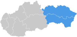
| Eastern Slovakia Východné Slovensko | |
|---|---|
| Region | |
 | |
| Country | |
| Area | |
| • Total | 15,728.4 km (6,072.8 sq mi) |
| Population | |
| • Total | 1,587,883 |
| • Density | 100/km (260/sq mi) |
| GDP | |
| • Total | €21.208 billion (2021) |
| NUTS code | SK04 |
| HDI (2022) | 0.817 very high · 4th |
Eastern Slovakia (Slovak: Východné Slovensko) is one of the four NUTS-2 Regions of Slovakia. It was created at the same time as were the Košice and Prešov regions. Eastern Slovakia is the least developed of the four NUTS-2 regions of Slovakia, with its GDP per capita being 54% of the European Union average (€16,300 per year).
Demographics
| Year | Pop. | ±% |
|---|---|---|
| 1970 | 1,228,029 | — |
| 1980 | 1,377,211 | +12.1% |
| 1991 | 1,480,459 | +7.5% |
| 2001 | 1,555,980 | +5.1% |
| 2011 | 1,606,250 | +3.2% |
| 2021 | 1,591,147 | −0.9% |
| Source: Censuses | ||
References
- Total area and land area, by NUTS 2 regions - km2
- "Number of inhabitants by gender (annually)".
- "EU regions by GDP, Eurostat". www.ec.europa.eu. Retrieved 18 September 2023.
- "Sub-national HDI - Area Database - Global Data Lab". hdi.globaldatalab.org. Retrieved 2021-07-20.
- "Statistical lexikon of municipalities 1970-2011" (PDF) (in Slovak).
- "Census 2021 - Population - Basic results". Statistical Office of the Slovak Republic. 2021-01-01.
This Slovak geography article is a stub. You can help Misplaced Pages by expanding it. |