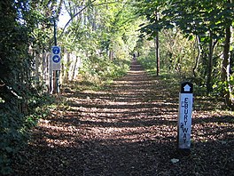
| Ebury Way Cycle Path | |
|---|---|
 | |
| Length | 3.5 mi (5.6 km) |
| Location | South-west Hertfordshire, England |
| Trailheads | Rickmansworth, Watford |
| Use | Cycling, Hiking |
The Ebury Way is a 3.5-mile (5.6 km) rail trail in Hertfordshire between Watford and Rickmansworth. The route crosses the Grand Union Canal and three rivers: the River Colne, the River Chess and the River Gade.
Passing lakes and fields in Rickmansworth, the shared-use path is frequented by walkers and cyclists. Its origin as the Watford and Rickmansworth Railway means that it is wide and largely flat. It forms part of National Cycle Route 61, which runs between Windsor to the south-west and Ware to the north-east. The Watford section of the Ebury Way up to its crossing of the Colne also forms part of NCR 6, so this section is jointly routed 6/61.
See also
External links
51°38′25″N 00°26′20″W / 51.64028°N 0.43889°W / 51.64028; -0.43889
| Watford | |||||||||||||||||||||
|---|---|---|---|---|---|---|---|---|---|---|---|---|---|---|---|---|---|---|---|---|---|
| Areas of Watford | |||||||||||||||||||||
| Transport |
| ||||||||||||||||||||
| Attractions & amenities |
| ||||||||||||||||||||
| Education |
| ||||||||||||||||||||
| Government | |||||||||||||||||||||
| Other | |||||||||||||||||||||