 | |
| Location | |
|---|---|
 | |
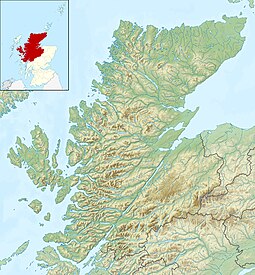
| Coordinates | 58°2′50.17″N 5°27′39.82″W / 58.0472694°N 5.4610611°W / 58.0472694; -5.4610611 |
| Physical geography | |
| Area | 39 hectares (0.15 sq mi) |
| Highest elevation | 46 metres (151 ft) |
| Administration | |
| Council area | Highland |
| Country | Scotland |
| Sovereign state | United Kingdom |
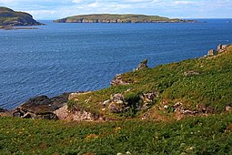
Eilean Mullagrach is an island in the Summer Isles of Scotland. It is located in Highland council area, in the northwestern part of the country, 800 km northwest of the United Kingdom capital London. It is the most northerly of the Summer Isles. Its area is 39 hectares and the maximum elevation is 46 metres (151 ft).
In 2024 the island, which has a small cabin and landing point with ladders for a small boat, was put up for sale for "offers over £500,000".
Bird life on the island includes kittiwakes, bonxies, shags and fulmars.
Notes
- The Gazetteer for Scotland states 75 ha and "Rick Livingstone's Tables" has 29 ha but the BBC's estimate corresponds more closely to an approximation from Ordnance Survey maps. Haswell-Smith does not include it in his tables of islands greater in area than 40 ha.
Gallery
-
 The landing point
-
 The cabin
-
 Grey seal near the island
-
 Eilean Mullagrach from Isle Ristol
References
- ^ "Island for sale: Limited viewing, sturdy footwear essential.". BBC News. Retrieved 13 June 2024.
- ^ Ordnance Survey. OS Maps Online (Map). 1:25,000. Leisure.
- "Eilean Mullagrach". Retrieved 18 April 2017.
- ^ "Mullagrach, Eilean". Gazetteer for Scotland. Retrieved 15 December 2018.
- "Rick Livingstone's Tables of the Islands of Scotland" (PDF). Argyll Yacht Charters. Retrieved 24 February 2019.
- Haswell-Smith, Hamish (2004). The Scottish Islands. Edinburgh: Canongate. ISBN 978-1-84195-454-7.
This Highland location article is a stub. You can help Misplaced Pages by expanding it. |