| This article needs additional citations for verification. Please help improve this article by adding citations to reliable sources. Unsourced material may be challenged and removed. Find sources: "El Hierro Airport" – news · newspapers · books · scholar · JSTOR (August 2024) (Learn how and when to remove this message) |
| El Hierro Airport Aeropuerto de El Hierro | |||||||||||
|---|---|---|---|---|---|---|---|---|---|---|---|
 | |||||||||||
 | |||||||||||
| Summary | |||||||||||
| Airport type | Public | ||||||||||
| Owner/Operator | Aena | ||||||||||
| Location | El Hierro | ||||||||||
| Elevation AMSL | 32 m / 103 ft | ||||||||||
| Coordinates | 27°48′53″N 017°53′13″W / 27.81472°N 17.88694°W / 27.81472; -17.88694 | ||||||||||
| Website | Airport of El Hierro | ||||||||||
| Map | |||||||||||
 | |||||||||||
| Runways | |||||||||||
| |||||||||||
| Statistics (2019) | |||||||||||
| |||||||||||
| Source:Spanish AIP at EUROCONTROL, Aena | |||||||||||
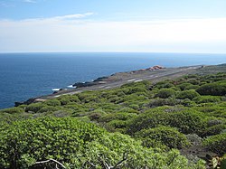
El Hierro Airport (Spanish: Aeropuerto de El Hierro, also known as Aeropuerto de Los Cangrejos) (IATA: VDE, ICAO: GCHI) is an airport located 9 km (5.6 mi) northeast of Valverde. It is the only existing airport on the Island of El Hierro, Canary Islands, Spain. It was inaugurated in December 1972.
However, in spite of its size and its limited timetable, it was the airport which had the greatest increase in number of passengers and merchandise in the Canary Islands in 2007.
The air traffic is national, and the flights are normally from/to Tenerife North and Gran Canaria. In 2011, the airport carried 170,225 passengers, with 4,674 operations and 135 tons of cargo.
History
The first aeronautical event in the island was on December 12, 1955, and it was the first rescue operation by the SAR in the Canary Islands too. It consisted of the evacuation of an ill person who had to be transported to Tenerife in a helicopter.
There was a real need for an airport on the island, so in 1962, some studies to locate the best place for the future airport were started, but the orography of the island is very complex, and there were not too many suitable places available.
Finally, the engineers decided to place the airport in a place called "Llano de los Cangrejos" located in the northeast of the Island, near its capital, Valverde.
Works to build the new installations began in 1967, building a runway (16-34), a small passenger terminal, and an apron. Once the works were finished, on November 11, 1972, the airport was inaugurated and dedicated to national air traffic of passengers and cargo. It was classified as a 2-C category (ICAO) or airport of third category.
The first airplane to land was a Do-27 of the Spanish Air Force, but the official inauguration was made by a DC-3 which carried the minister Julio Salvador y Días-Benjumena.
The first regular connection was inaugurated by Iberia, starting operations on December 19, 1972, with a Fokker F-27 commanded by Vicente Ramos Hernández, which made the route from Tenerife North - El Hierro - Tenerife North.
During 1989 and 1990, a new control tower was built on the west side of the runway, the old one was demolished, and at the same time a new passenger terminal was built. In July, 1992, instead of Iberia, BinterCanarias started to operate the route from Tenerife North to El Hierro with an ATR-72. For that reason, the runway had to be extended to 1205 metres (3953 ft) length. This extension allowed an increase in the number of passengers and operations. It has a short 1250 m (4100 ft) runway, which limits the airport to handling regional turboprop aircraft, however if required it can handle a 737 or A320-family jet.
Infrastructure
The control tower is located in the western part of the island, opposite to the terminal - where an air traffic controller and the maintenance technicians work. In 2008, works to renovate the control tower began, with the aim of modernizing the installations. At present, it has the SACTA 3.5 system, which allows radar visualization of the radar data.
Airlines and destinations
| Airlines | Destinations |
|---|---|
| Binter Canarias | Gran Canaria, Tenerife–North |
| CanaryFly | Gran Canaria, Tenerife–North |
Statistics
| Graphs are unavailable due to technical issues. Updates on reimplementing the Graph extension, which will be known as the Chart extension, can be found on Phabricator and on MediaWiki.org. |
References
- ^ EAD Basic
- "AENA". Archived from the original on 24 December 2013. Retrieved 20 December 2012.
- "AENA". AENA. Archived from the original on 2013-12-25.
- "El mundo de la aviacion".
- aena.es retrieved 6 April 2022
- ^ "LIST OF PUBLIC SERVICE OBLIGATIONS" (PDF). Aeroroutes.com. 11 March 2024. Retrieved 4 January 2025.
- aena.es retrieved 6 April 2022
External links
- El Hierro Airport Official Website - (in English)
| Airports in Spain | |||||
|---|---|---|---|---|---|
| International |
| ||||
| Domestic | |||||
| Unscheduled | |||||
| Statistics | |||||