Census-designated place in Wisconsin, United States
| Ellison Bay, Wisconsin | |
|---|---|
| Census-designated place | |
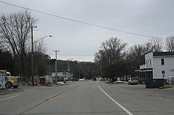
 Looking south at downtown Ellison Bay on WIS 42 Looking south at downtown Ellison Bay on WIS 42 | |
 | |
| Coordinates: 45°15′17″N 87°04′17″W / 45.25472°N 87.07139°W / 45.25472; -87.07139 | |
| Country | United States |
| State | Wisconsin |
| County | Door |
| Town | Liberty Grove |
| Founded | 1872 |
| Area | |
| • Total | 2.662 sq mi (6.89 km) |
| • Land | 2.662 sq mi (6.89 km) |
| • Water | 0 sq mi (0 km) |
| Population | |
| • Total | 249 |
| • Density | 94/sq mi (36/km) |
| Time zone | UTC-6 (Central (CST)) |
| • Summer (DST) | UTC-5 (CDT) |
| ZIP Code | 54210 |
| Area code | 920 |
Ellison Bay is an unincorporated community and census-designated place in northern Door County, Wisconsin, United States, within the town of Liberty Grove and is located on Highway 42 along the Green Bay. As of the 2020 census, its population is 249. Sur La Baie, one of Wisconsin's largest and most expensive homes, is located nearby.
History
A Native American name for the bay was Joe-Sahbe Bay, after a son of the Potowatomi Chief Neatoshing, who was also known as Mishicott. Joe-Sahbe means "Feather of the rolling cloud".
The community was founded in 1872 by John Eliasen, a Danish immigrant. Lumber and fishing were important businesses in the 19th century, replaced by fruit growing in the early 20th century, and today tourism is the main business.
Education
Gibraltar Area Schools serves the community. Gibraltar Elementary School and Gibraltar Secondary School are the two schools.
Demographics
| This section needs expansion. You can help by adding to it. (January 2023) |
| Census | Pop. | Note | %± |
|---|---|---|---|
| 2010 | 165 | — | |
| 2020 | 249 | 50.9% | |
| U.S. Decennial Census | |||
Attractions
Important attractions include The Clearing, a private center for adult education that was originally established by Jens Jensen, a prominent landscape architect. It is listed on the National Register of Historic Places. Other attractions include the Mink River four miles south, Turtle Ridge Gallery, a cooking school, former Church turned Asian art gallery turned coffee shop, and pottery studios.
Ellison Bluff
Ellison Bluff County Park includes a scenic hiking trail, a picnic area, and a fenced catwalk. The bluff area has wildflowers and trees. One cedar was found to be over 250 years old. Rough-winged swallows hunt for insects along the bluff. Other birds seen at the park include American redstart, great-crested flycatcher, broad-winged hawk, wood thrush, scarlet tanager, yellow-throated vireo, and pileated woodpecker. 170 acres of the park is protected as the Ellison Bluff State Natural Area.
2006 explosion
On July 10, 2006, an explosion leveled the 136-year-old Pioneer Store, killing two vacationers and injuring 13 others. The blast also burned down one cottage and damaged another. It is believed a propane gas leak caused the explosion, which may have resulted from a contractor damaging unmarked underground propane lines.
Climate
| ||||||||||||||||||||||||||||||||||||||||||||||||||||||||||||||||||||||||||||||||||||||||||||||||||||||||||||||||||||||||||||
Gallery
-
 Post office
-
 Looking north in downtown Ellison Bay
-
 Northern part of the bay
-
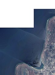
 Ellison Bay, below, taken by a crewmember of ISS Expedition 38, February 22, 2014
-
 Sunset over the bay
-
 1908 postcard depicting Ellison Bay
-
 c. 1919 postcard depicting Ellison Bay
References
- "Ellison Bay, Wisconsin". Geographic Names Information System. United States Geological Survey, United States Department of the Interior.
- Ellison Bay, Wisconsin
- "U.S. Census website". U.S. Census Bureau. Retrieved March 30, 2011.
- Indian ancestry comes alive by Jeanette Heyroth, Mishicot News feature of Manitowoc Herald-Times Manitowoc, Wisconsin, March 16, 2003, page 29 and Romance of Wisconsin Place Names by Robert E. Gard and L. G. Sorden, New York: October House, Inc. 1968, page 37
- The Wisconsin Archeologist, Volume 19, No 2, page 51
- History of Door County, Wisconsin by By Hjalmar Rued Holand, Chicago: S. J. Clarke Publishing, 1917, pages 372–373 and Door County Links, Grand View Condominiums, (Archived September 19, 2013)
- "Gibraltar Area Schools, Gibraltar Area School District, (Archived July 14, 2014)
- "Census of Population and Housing". Census.gov. Retrieved January 1, 2023.
- "Home". turtleridgegallery.com.
- Ellison Bluff County Park, co.door.wi.gov
- Great Wisconsin Birding and Nature Trail - Lake Michigan Region by the Wisconsin Bird Conservation Partnership, waypoint 8, Ellison Bluff County Park & State Natural Area
- Ellison Bluff (No. 378), Wisconsin State Natural Areas Program, Wisconsin Department of Natural Resources
- "Explosion Kills Two Guests at the Cedar Grove Resort in Ellison Bay, Wisconsin; Likely Caused by Propane Leak"
- "NASA EarthData Search". NASA. Retrieved January 30, 2016.
Sources
- Around the Shores of Lake Michigan: A Guide to Historic Sites by Margaret Beattie Bogue (1985, University of Wisconsin Press)
External links
| Municipalities and communities of Door County, Wisconsin, United States | ||
|---|---|---|
| County seat: Sturgeon Bay | ||
| City |  | |
| Villages | ||
| Towns | ||
| CDPs | ||
| Other communities | ||
| Footnote | ‡Partially located in Kewaunee County | |


