Endell Street, originally known as Belton Street, is a street in London's West End that runs from High Holborn in the north to Long Acre and Bow Street, Covent Garden, in the south. A long tall narrow building on the west side is an 1840s-built public house, the Cross Keys, Covent Garden.
Location

Endell Street is crossed only by Shorts Gardens and Shelton Street. Betterton Street intersects between these on the eastern side. The northern end of the street is in the London Borough of Camden, the south in the City of Westminster. The street is an avenue with very tall, mature plane trees, widely spaced; it now equals the B401 (which had included Bow and Wellington Streets) and is one-way, southbound.
History
The land on which the southern part of Endell Street is built was originally owned by William Short, who leased it to Esmé Stewart, 3rd Duke of Lennox, in 1623–24. Lennox House was built on the site which eventually passed to Sir John Brownlow who began to build from 1682. Belton Street was created, named after the Brownlow's country seat in Lincolnshire, Belton House. Henry Wheatley writes that the southern end of the street from Castle Street to Short's Gardens was originally known as Old Belton Street, the northern end from Short's Gardens to St Giles, was known as New Belton Street.
In the seventeenth century, Queen Anne is supposed to have bathed in the waters from a medical spring there at a site known as Queen Anne's Bath.
The modern Endell Street was created according to the reforming plans of architect James Pennethorne.
Charles Lethbridge Kingsford states that the street was built in 1846 when Belton Street was widened and extended northwards to Broad Street (now in High Holborn). The street is believed to have been named after the Reverend James Endell Tyler, rector of St Giles in the Fields in the 1840s. The British Lying-In Hospital was relocated to a purpose-built building on Endell Street in 1849.
Listed buildings

There are eight listed buildings of the street, including:
Lavers and Barraud stained-glass studio
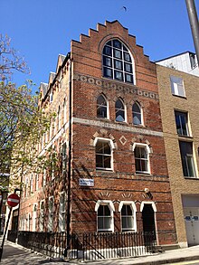
The Jewell and Withers Building at 22 Endell Street is a Grade II listed building. Located on the corner of Betterton Street and Endell Street, the polychromatic brick-and-stone Gothic Revival structure, cited as an early example of the style, was designed as a studio for the stained-glass firm Lavers and Barraud in 1859, and is included, together with the attached cast-iron railings, on the National Heritage register. The crow-step gable, facing Betterton Street, has a significant contemporary artwork by painter Brian Clarke, in the form of a three-light stained-glass window. The Post-modern artwork, which references the building's original function as a stained glass studio, was commissioned as part of the 1981 refurbishment of the building, undertaken by architects Rock Townsend. The artwork was part-funded by the British Crafts Council, and fabricated in Germany under Clarke’s supervision. It was installed in 1981, and was notably designed to be equally visually effective both by night and by day, making graphic use of complex leading, and deploying different types of mouth-blown glass to particular effect.
Cross Keys public house
The Cross Keys public house at No.31, constructed 1848–49, is a Grade II listed building.
Latchfords Timber Yard
The nineteenth-century Latchfords Timber Yard and attached timber sheds at No.61 are Grade II listed.
Swiss Protestant Church
The Swiss Protestant Church at No.79 was designed by George Vulliamy and built 1853–4. It is also Grade II listed.
Inhabitants
The watercolour painter William Henry Hunt was born at "8 Old Belton Street" (No. 7) in 1790.
Hospitals of Endell Street
British Lying-in Hospital
Main article: British Lying-In HospitalFounded in 1749, this maternity hospital was built at No.24 in 1849; it closed in 1913.
St Paul's Hospital
Main article: St Paul's Hospital, Endell StreetFounded in 1898, this urology hospital took over the premises at No.24 after the British Lying-In Hospital closed; St Paul's Hospital closed in 1992.
Endell Street Military Hospital
Main article: Endell Street Military Hospital
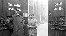
During the first world war a military hospital operated from No.36, staffed entirely by women. The hospital was opened in 1915 by suffragists Dr Flora Murray and Dr Louisa Garrett Anderson and treated 24,000 patients and carried out more than 7,000 operations. It closed in 1919.
Clubs

The Caravan Club
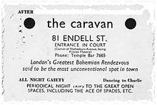
Main article: The Caravan Club (Endell Street)The basement of No.81 was home from July 1934 to the Caravan Club, which advertised itself as "London's Greatest Bohemian Rendezvous said to be the most unconventional spot in town", code for being gay-friendly. The club helpfully promised "All night gaiety". It was run by Jack Rudolph Neaves, known as Iron Foot Jack on account of the metal leg brace he wore, and was frequented by both gay men and lesbian women. It was financed by small-time criminal Billy Reynolds.
The club came to the attention of the police almost straight away and in August local residents complained "It's absolutely a sink of iniquity." The club was raided on 25 August, with men arrested. Their trial at Bow Street Magistrates' Court caused a sensation reported in the News of the World.
In July 2024, a property developer proposed that a rainbow plaque be added to the Endell Street site, now known as The Sail Loft.
The Hospital Club
Main article: The Hospital ClubThe Hospital Club opened in 2003 at No.24 to serve the members of London's media and creative industries. It was on the site of the former St Paul's Hospital. It was used by the rock band Radiohead to record parts of their 2007 album In Rainbows and the 2008 live video In Rainbows – From the Basement. In 2020, the club closed permanently owing to the effects of the COVID-19 pandemic and other "extenuating circumstances".
References
- ^ Kingsford, Charles Lethbridge. (1925). The early history of Piccadilly Leicester Square Soho & their neighbourhood based on a plan drawn in 1585 and published by the London Topographical Society in 1925. Cambridge: University Press. p. 35.
- ^ Wheatley, Henry B. (1891). London past and present: Its history, associations, and traditions. Vol. I. London: John Murray. Cambridge University Press reprint, 2011. p. 157. ISBN 9781108028066.
- ^ Hibbert, Christopher (2010). The London Encyclopaedia. London: Pan Macmillan. p. 273. ISBN 978-0-230-73878-2.
- "Commercial Street | British History Online". www.british-history.ac.uk.
- "Information Leaflet Number 35 Records of patients in London hospitals" (PDF). London Metropolitan Archives. City of London. Archived from the original (PDF) on 1 April 2016. Retrieved 3 September 2016.
- Ryan, Thomas (1885). The History of Queen Charlotte's Lying-in Hospital. pp. ix–xv.
- Historic England. "NUMBER 22 AND ATTACHED RAILINGS (1078289)". National Heritage List for England. Retrieved 8 September 2014.
- Harrison, Martin (1982). "Can We Expect a Stained Glass Revival?". In Margetts, Martina (ed.). Crafts Magazine. Vol. 59. United Kingdom: Crafts Council of Great Britain. pp. 10–11.
- Powell, Kenneth (1994). "Architectural Artist". In Hodges, Nicola (ed.). Brian Clarke: Architectural Artist. Academy Editions: art and design monographs. Great Britain: Academy Group Ltd. p. 15. ISBN 9781854903433.
- "News". Building Design (September). BD: 3. 18 September 1981.
- Historic England. "CROSS KEYS PUBLIC HOUSE (1078290)". National Heritage List for England. Retrieved 6 September 2014.
- Historic England. "LATCHFORDS TIMBER YARD INCLUDING ATTACHED TIMBER SHEDS (1078292)". National Heritage List for England. Retrieved 6 September 2014.
- Historic England. "SWISS PROTESTANT CHURCH (1078294)". National Heritage List for England. Retrieved 6 September 2014.
- Waterston, Jane Elizabeth (1983). The Letters of Jane Elizabeth Waterston, 1866-1905. Van Riebeeck Society, The. ISBN 9780620073752.
- "British Lying-In Hospital". Lost Hospitals of London. Retrieved 13 July 2018.
- St Paul’s Hospital for Skin and Genito-Urinary Diseases. "St Paul's Hospital for Skin and Genito-Urinary Diseases". www.ucl.ac.uk. UCL Bloomsbury Project. Retrieved 8 June 2018.
- Endell Street, London: Only All-Female Run Military Hospital. BBC, 3 February 2014. Retrieved 5 September 2014.
- Hacker, Barton; Vining, Margaret. (Eds.) (2012). A Companion to Women's Military History. Brill. p. 193. ISBN 978-90-04-21217-6.
- Houlbrook, Matt. (2006). Queer London: Perils and Pleasures in the Sexual Metropolis, 1918–1957. Chicago: University of Chicago Press. p. 71. ISBN 978-0-226-35462-0.
- Jennings, Rebecca. (2007). Tomboys and Bachelor Girls: A Lesbian History of Post-War Britain 1945–71. Manchester: Manchester University Press. p. 110. ISBN 978-0-7190-7544-5.
- Houlbrook, Matt (15 October 2006). Queer London: Perils and Pleasures in the Sexual Metropolis, 1918-1957. University of Chicago Press. ISBN 9780226354620 – via Google Books.
- Norman, Paul (23 July 2024). "Rainbow Plaque Sought as Part of Office Makeover at Pioneering London LGBTQ+ Venue". CoStar News. Retrieved 14 September 2024.
- "Robert Irving Burns applies for Rainbow Plaque to commemorate LGBTQ+pioneering". London Daily News. 25 July 2024. Retrieved 14 September 2024.
- About Us. The Hospital Club. Retrieved 6 September 2014.
- Paytress, Mark (1 January 2008). "Chasing Rainbows". Mojo.
- "Radiohead to Stream 2008 Live 'In Rainbows' Film". SPIN. 4 June 2020. Retrieved 20 September 2021.
- "h Club London to close permanently". The Stage. Retrieved 20 September 2021.
External links
![]() Media related to Endell Street, London at Wikimedia Commons
Media related to Endell Street, London at Wikimedia Commons
51°30′52″N 0°07′28″W / 51.51442°N 0.12441°W / 51.51442; -0.12441
Categories: