| Ephrata | |
|---|---|
| village | |
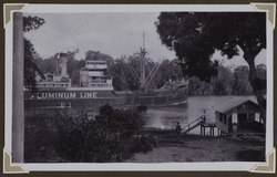
 Bauxite ship on the Cottica River near Ephrata Bauxite ship on the Cottica River near Ephrata | |
| Country | |
| District | Commewijne District |
| Resort | Bakkie |
| Area | |
| • Total | 81 km (31 sq mi) |
| Elevation | 0 m (0 ft) |
| Time zone | UTC-3 (AST) |
| Climate | Af |
Ephrata was a village located within the Bakkie resort of the Commewijne District of Suriname.
Ephrata started as a sugar plantation, and had been documented as early as 20 November 1708. The plantation is located on the Cottica River. The surname "van Ephrata" (English: from Ephrata) is often used by Boni Maroons.
References
- ^ "Kaart van de Plantagie Ephrata en een daaraan gelegen stuk land". Atlas of Mutual Heritage.nl (in Dutch). Retrieved 21 May 2020.
- "Plantage Ephrata". Suriname Plantages (in Dutch). Retrieved 21 May 2020.
- Silvia de Groot (1970). "Rebellie der Zwarte Jagers. De nasleep van de Bonni-oorlogen 1788-1809". De Gids.
| Resorts and places in Commewijne District, Suriname | |
|---|---|
| Alkmaar | |
| Bakkie | |
| Johan & Margaretha | |
| Meerzorg | |
| Nieuw Amsterdam | |
| Tamanredjo | |
| Italic denotes the capital *Abandoned settlement | |
This Suriname location article is a stub. You can help Misplaced Pages by expanding it. |