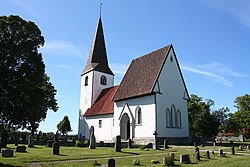
| Lummelunda Lummelunda and Etebols | |
|---|---|
 Lummelunda Church Lummelunda Church | |
 | |
| Coordinates: 57°46′21.3″N 18°26′39.0″E / 57.772583°N 18.444167°E / 57.772583; 18.444167 | |
| Country | Sweden |
| Province | Gotland |
| County | Gotland County |
| Municipality | Gotland Municipality |
| Area | |
| • Total | 23.79 km (9.19 sq mi) |
| Population | |
| • Total | 447 |
| Time zone | UTC+1 (CET) |
| • Summer (DST) | UTC+2 (CEST) |
| Website | lummelundaannorlunda |
Lummelunda (sometimes referred to as Lummelunda and Etebols) is a populated area, a socken (not to be confused with parish), on the Swedish island of Gotland. It comprises the same area as the administrative Lummelunda District, established on 1 January 2016.
Lummelunda is most noted for the Lummelunda Cave, one of the longest caves in Sweden, and the mill with the largest water wheel in northern Europe.
Geography
Lummelunda is on the northwest coast of Gotland with the Lummelunda stream to the south, approximately 17 km (11 mi) north of Visby. The land is mainly plains with high and steep, forested cliffs to the north. Lummeluda is a farming district. On the Lummelunda coast next to the local hostel is Nyhamn harbor and fishing village, dating back to the 17th centurtry.
One of Sweden's longest caves, the Lummelunda Cave, is situated at Lummelunda. The cave is part of a nature reserve with the same name as the cave, Lummelundagrottan. The reserve, established in 1989, is 17 ha (42 acres) and includes the cave and the ground above it.
The Lummelunda Church is medieval. As of 2019, Lummelunda Church belongs to Stenkyrka parish in Norra Gotlands pastorat, along with the churches in Stenkyrka, Martebo and Tingstäde.
One of the asteroids in the asteroid belt, 10132 Lummelunda, is named after this settlement.
History
The name is probably from the vicarage, in 1350 known as Lomalunda. The meaning of the first part of the name is unknown, the second part lund means "grove", can have been intended for a sacred grove.
A couple of graves from the Stone Age has been found at Lummelunda, as well as fifteen grave fields from the Iron Age and ground grooves on both boulders and slabs.
During the use of the Swedish allotment system, the boatswains of Lummelunda were part of the 1st Gotlandic Boatswain Company.
Mills

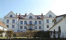
The water in the Lummelunda stream has been used for industry since the Middle Ages. Three mills are named, the Topmost (Översta kvarn), the Middle (Mellersta kvarn) and the Lowest (Nedersta kvarn). The water wheels were used for grinding grains, saw mills and textile mills for manufacturing wadmal. The height of the industry at Lummelunda was during the 17th century, when ironworks at the stream processed iron ore shipped from Utö in the Stockholm archipelago. As of 2015, only the Topmost Mill remains. It has the largest water wheel in northern Europe. The adjacent Lummelund Manor was built in the 1805.
References
- "Småorter 2010" (PDF). www.scb.se. Statistiska Central Byrån. Retrieved 7 June 2014.
- Carlquist, Gunnar, ed. (1947–1955). Svensk uppslagsbok (in Swedish) (2nd ed.). Malmö: Förlagshuset Norden. Retrieved 7 June 2014.
- "Gotland i siffror 2015" [Gotland in numbers 2015]. www.gotland.se. Gotland Municipality. Retrieved 25 May 2016.
- The exact extent of the socken, now district, can be obtained by clicking on Kartinställningar and check the Socken box in the menu of this map from the Swedish National Heritage Board database.
- "Förordning om district" [Regulation of districts] (PDF). Ministry of Finance. 17 June 2015. Archived from the original (PDF) on 30 September 2018. Retrieved 24 May 2016.
- "Lummelunda kyrka". www.guteinfo.se. Guteinfo.se. Retrieved 7 June 2014.
- Enderborg, Bernt. "Nyhamns fiskeläge". www.guteinfo.com. Guteinfo. Retrieved 13 January 2019.
- "Bildande av naturresrevatet Lummelundagrotta i Lummelunda socken, Gotlands Kommun" (PDF). www.lansstyrelsen.se (in Swedish). The County Administrative Boards of Gotland County. 20 March 1989. Retrieved 18 June 2015.
- Lagerlöf, Erland; Svahnström, Gunnar (1973). Gotlands kyrkor [Gotland's Churches] (in Swedish). Stockholm: Rabén & Sjögren. pp. 204–206. ISBN 91-29-41035-5. SELIBR 7232718.
- "Församlingar på Gotland". www.svenskakyrkan.se. Church of Sweden. Retrieved 11 January 2019.
- "Visby stifts indelning 2018". www.svenskakyrkan.se. Church of Sweden. Retrieved 11 January 2019.
- "JPL Small-Body Database Browser". NASA. Retrieved 2008-05-04.
- Wahlberg, Mats (2003). Svenskt ortnamnslexikon. Uppsala: Institutet för språk och folkminnen. Stockholm: Wahlström & Widstrand. ISBN 91-7229-020-X.
- Sjögren, Otto, ed. (1931). Sverige: geografisk beskrivning. D. 2, Östergötlands, Jönköpings, Kronobergs, Kalmar och Gotlands län (in Swedish). Stockholm: Wahlström & Widstrand. Retrieved 7 June 2014.
- "Lummelunda, sökresultat". www.fmis.raa.se. Riksantikvarieämbetet. Retrieved 7 June 2014.
- "Lummelunda socken". www.historiska.se. Historiska museet. Retrieved 7 June 2014.
- "1:a Gotlands båtsmanskompani 09". Riksarkivet. Nationell Arkivdatabas. Retrieved 7 June 2014.
- Högman, Hans. "Svenska regementen under indelningsverket". www.algonet.se. Hans Högmans Släktforskning. Archived from the original on 24 December 2012. Retrieved 7 June 2014.
- Enderborg, Bernt. "Lummelunds Bruk". www.guteinfo.com. Guteinfo. Retrieved 18 June 2015.
- Lundberg, Erik B. (1939). Lummelunds bruk: anteckningar om de gotländska järnbruken. Jernkontorets bergshistoriska skriftserie, 0347-4283 ; 8. Stockholm: Jernkontoret.
