| Fannaråki | |
|---|---|
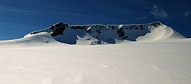
 Fannaråki seen from Fannaråkbreen (glacier) at the mountains northern base. Summit to the right. Fannaråki seen from Fannaråkbreen (glacier) at the mountains northern base. Summit to the right. | |
| Highest point | |
| Elevation | 2,068 m (6,785 ft) |
| Prominence | 450 m (1,480 ft) |
| Coordinates | 61°30′59″N 07°54′29″E / 61.51639°N 7.90806°E / 61.51639; 7.90806 |
| Geography | |
  | |
| Location | Luster, Vestland, Norway |
| Parent range | Hurrungane |
| Topo map | 1518 III Sygnefjell |
Fannaråki (or Fannaråken) is a mountain in the municipality of Luster in Vestland county, Norway. The 2,068-metre (6,785 ft) tall mountain is located in the Jotunheimen National Park, just south of the lake Prestesteinsvatnet and the Sognefjellsvegen road. This mountain is located about 6 kilometres (3.7 mi) north of the Skagastølstindane mountains (Store Skagastølstind, Vetle Skagastølstind, Midtre Skagastølstind, Sentraltind, Store Styggedalstind, and Jervvasstind).
Name
The first element is derived from the word fonn which means "glacier made of snow" and the last element is the finite form of råk which means "mountain ridge".
Guidebooks
- Dyer, Anthony; Baddeley, John; Robertson, Ian H. (2006). Walks and Scrambles in Norway. Rockbuy Limited. ISBN 978-1-904466-25-3.
- Pollmann, Bernhard (2000). Norway South: Rother Walking Guide. Bergverlag Rudolf Rother. ISBN 978-3-7633-4807-7.
- Baxter, James. Scandinavian Mountains and Peaks Over 2000 Metres in the Hurrungane. Edinburgh: Scandinavian Publishing. ISBN 978-0-9550497-0-5.
Climate
| Climate data for Fannaråki, Norway (1932-2014) | |||||||||||||
|---|---|---|---|---|---|---|---|---|---|---|---|---|---|
| Month | Jan | Feb | Mar | Apr | May | Jun | Jul | Aug | Sep | Oct | Nov | Dec | Year |
| Record high °C (°F) | 1.9 (35.4) |
1.2 (34.2) |
6.7 (44.1) |
6.9 (44.4) |
12.8 (55.0) |
18.5 (65.3) |
17.2 (63.0) |
16.9 (62.4) |
12.2 (54.0) |
11.5 (52.7) |
3.8 (38.8) |
2.5 (36.5) |
18.5 (65.3) |
| Mean daily maximum °C (°F) | −8.7 (16.3) |
−8.9 (16.0) |
−7.2 (19.0) |
−5.1 (22.8) |
−0.4 (31.3) |
3.2 (37.8) |
5.3 (41.5) |
4.6 (40.3) |
0.9 (33.6) |
−2.5 (27.5) |
−5.7 (21.7) |
−7.5 (18.5) |
−2.6 (27.3) |
| Daily mean °C (°F) | −11.2 (11.8) |
−11.5 (11.3) |
−10.0 (14.0) |
−8.0 (17.6) |
−3.2 (26.2) |
0.4 (32.7) |
2.7 (36.9) |
2.3 (36.1) |
−1.2 (29.8) |
−4.5 (23.9) |
−7.9 (17.8) |
−9.8 (14.4) |
−5.2 (22.7) |
| Mean daily minimum °C (°F) | −13.4 (7.9) |
−13.9 (7.0) |
−12.4 (9.7) |
−10.3 (13.5) |
−5.6 (21.9) |
−1.8 (28.8) |
0.5 (32.9) |
0.2 (32.4) |
−3.1 (26.4) |
−6.5 (20.3) |
−10.0 (14.0) |
−12.0 (10.4) |
−7.4 (18.8) |
| Record low °C (°F) | −33.0 (−27.4) |
−27.3 (−17.1) |
−25.2 (−13.4) |
−23.2 (−9.8) |
−21.0 (−5.8) |
−12.2 (10.0) |
−8.2 (17.2) |
−8.2 (17.2) |
−13.0 (8.6) |
−20.7 (−5.3) |
−22.0 (−7.6) |
−26.3 (−15.3) |
−33.0 (−27.4) |
| Average precipitation mm (inches) | 100.9 (3.97) |
97.2 (3.83) |
83.6 (3.29) |
85.2 (3.35) |
59.4 (2.34) |
76.1 (3.00) |
108.4 (4.27) |
117.2 (4.61) |
113.2 (4.46) |
101.9 (4.01) |
103.2 (4.06) |
114.4 (4.50) |
1,160.6 (45.69) |
| Average precipitation days (≥ 1 mm) | 17.2 | 15.2 | 15.4 | 15.2 | 12.8 | 14.0 | 17.4 | 16.7 | 17.4 | 18.0 | 18.6 | 19.4 | 197.4 |
| Average relative humidity (%) | 85.6 | 85.0 | 82.4 | 86.3 | 86.4 | 85.9 | 87.8 | 87.8 | 89.3 | 86.4 | 86.4 | 87.6 | 86.4 |
| Source: Norwegian Meteorological Institute | |||||||||||||
References
- ^ Store norske leksikon. "Fannaråki" (in Norwegian). Retrieved 2010-09-11.
- "Seklima - Observations and weather statistics". Norwegian Meteorological Institute. Retrieved March 17, 2023.
External links
This article about a mountain, mountain range, or peak in Vestland is a stub. You can help Misplaced Pages by expanding it. |