| This article needs additional citations for verification. Please help improve this article by adding citations to reliable sources. Unsourced material may be challenged and removed. Find sources: "Al-Faw peninsula" – news · newspapers · books · scholar · JSTOR (September 2009) (Learn how and when to remove this message) |
 | |
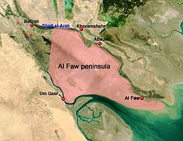
The Al-Faw peninsula (Arabic: شبه جزيرة الفاو; also transliterated as Fao or Fawr) is a peninsula in the Persian Gulf, located in the extreme southeast of Iraq. The marshy peninsula is 20 km (12 mi) southeast of Iraq's third largest city, Basra, and is part of a delta for the Shatt al-Arab (Arvand Rud) river, formed by the confluence of the major Euphrates and Tigris rivers. The al-Faw peninsula borders Iran to the northeast, with the cities of Abadan and Khorramshahr on the opposite side of the Shatt al-Arab, and Kuwait to the southwest, opposite from Bubiyan Island and Warbah Island, near the Iraqi city of Umm Qasr.
Al-Faw, the only significant town on the peninsula and its namesake, is a fishing town and port which during Saddam Hussein's presidency featured the main naval base of the Iraqi Navy. The remainder of the al-Faw peninsula is otherwise lightly inhabited, with few civilian buildings or settlements and most of its few residents involved in the fishing, oil, or shipping industries. It is the site of a number of important oil installations, most notably Iraq's two main oil tanker terminals: Khor al-Amaya and Mina al-Bakr, due to its chief importance as a strategic location controlling access to the Shatt al-Arab waterway and thus access to the port of Basra.
Iran-Iraq War
Main articles: Operation Dawn 8, First Battle of al-Faw, and Second Battle of al-FawDuring the Iran–Iraq War in the 1980s, al-Faw was bitterly contested due to its strategic location at the head of the disputed Shatt al-Arab waterway and was the site of many large-scale battles. On February 11, 1986, the Iranians capitalized on the weakness of the Iraqi defences located at the southernmost tip of the peninsula by launching a surprise attack against Iraqi troops defending al-Faw. The Iraqi units in charge of the defences consisted mostly of poorly trained Iraqi Popular Army conscripts that collapsed when they were suddenly attacked by Iranian Pasdaran (Revolutionary Guard) forces.
It marked the first time that the Iranians had successfully invaded and occupied Iraqi territory. The Iranians defeated several Iraqi Republican Guard counter-offensives and managed to hang on to their foothold.
The occupation of al-Faw placed Basra at risk of being attacked. The Iranians also used the peninsula as a launch pad for Silkworm missiles which were deployed against shipping and oil terminals in the Persian Gulf, and also against Kuwait, which supported Iraq throughout the war.
On April 17, 1988, the newly-restructured Iraqi Army began a major operation, "Ramadan Mubarak," which was aimed to clear the Iranians out of the peninsula. The Iraqis concentrated well over 100,000 troops from the Republican Guard versus 15,000 second-rate Iranian Basij soldiers.
By using sarin nerve gas, artillery barrages and air bombardments, the Iraqis eventually expelled the Iranians from the peninsula within 35 hours, with much of their equipment captured intact. The event was marked as an official national holiday under the former regime of Saddam Hussein, celebrated as the Faw City Liberation Day.
Anglo-American occupation
The 1991 Gulf War was fought south and west of al-Faw, but the peninsula's military installations were heavily bombed by Allied forces during the conflict. The Allied forces effectively closed down all of Iraq's shipping activities and thus rendered its access to the Shatt al-Arab and the Persian Gulf useless.
The peninsula was one of the first targets of the Coalition forces in the 2003 invasion of Iraq, with British, American and Polish troops involved. Forces from the Royal Marines, US Marines and the Polish GROM staged a successful midnight amphibious assault on the peninsula. All of them were attached to the British 3 Commando Brigade. Their goal was to secure the port of Umm Qasr to allow humanitarian goods to be shipped in, and to secure the key oil installations located in the area before they could be sabotaged by retreating Iraqi forces. The Mina al-Bakr oil terminal was seized by SEAL Teams 8 and 10; as well as US Navy EOD personnel. The Khor al-Amaya oil terminal was seized by GROM operators. The peninsula fell quickly with minimal Iraqi resistance, but unexpected fierce resistance in Umm Qasr required several days of fighting before the town had been secured.
The British, based at Camp Driftwood, provided the security and countersmuggling force on land, and the American forces providing maritime assistance. Camp Driftwood was handed to Iraqi control in March 2007 by troops from 1st Battalion The Yorkshire Regiment.
See also
- List of places in Iraq
- Iran–Iraq War
- Al-Faw Palace
- Al-Fao artillery system
- Al-Faw
References
- Pollack, Kenneth M. (2004). Arabs at war: military effectiveness, 1948–1991. University of Nebraska Press. p. 225. ISBN 0-8032-8783-6.
- Harris, Shane; Matthew M. Aid (2013-08-26). "Exclusive: CIA Files Prove America Helped Saddam as He Gassed Iran". Foreign Policy. Archived from the original on 2013-08-26. Retrieved 2013-08-26.
- Podeh, Elie; Pôde, Ēlî (2011-06-30). The Politics of National Celebrations in the Arab Middle East. Cambridge University Press. p. 142. ISBN 9781107001084.
- Operations in Iraq: Lessons for the Future. Ministry of Defence/National Archives. "The Al Faw Peninsula Operation" (sidebar), p. 11. Retrieved 16 January 2020 – via The Internet Archive.
- ^ Neville, Leigh (2008). Special Operations Forces in Iraq. Oxford: Osprey Publishing. p. 24. ISBN 978-1-84603-357-5.
29°58′28″N 48°27′51″E / 29.97444°N 48.46417°E / 29.97444; 48.46417
Category: