| Carbondale Area School District | |
|---|---|
 | |
| Address | |
| Business Route 6/101 Brooklyn Street
Carbondale, Lackawanna County, Pennsylvania, 18407-2207 United States | |
| District information | |
| Type | Public |
| Students and staff | |
| District mascot | Chargers |
| Other information | |
| Website | gateway |
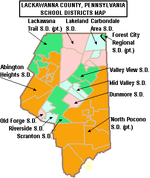
The Carbondale Area School District is a small, suburban school district that provides education services to the children residing in the City of Carbondale and Fell Township in Lackawanna County, Pennsylvania. The district encompasses an area of 18.6 square miles (48 km). The school district had a population of 11,641, according to the 2000 federal census. By 2010, the district's population declined to 11,065 people. The educational attainment levels for the Carbondale Area School District population (25 years old and over) were 87.4% high school graduates and 16.4% college graduates. The district is one of the 500 public school districts of Pennsylvania an done of 12 districts operating in Lackawanna County.
According to the Pennsylvania Budget and Policy Center, 64.7% of the district's pupils lived at 185% or below the Federal Poverty level as shown by their eligibility for the federal free or reduced price school meal programs in 2012. In 2009, the District residents' per capita income was $15,174, while the median family income was $35,833. In the United States the median family income was $49,445, in 2010. In Lackawanna County, the median household income was $43,673. By 2013, the median household income in the United States rose to $52,100.
According to district officials, the Carbondale Area School District provided basic educational services to 1,615 pupils in 2011-12. The district employed: 121 teachers, 94 full-time and part-time support personnel, and 6 administrators during the 2011-12 school year. The Carbondale Area School District received $11 million in state funding in the 2011-12 school year. Per Carbondale Area School District administrative officials, during the 2005-06 school year, the district provided basic educational services to 1,458 pupils. The district students are 95% white, 1% Asian, 2% black and 3% Hispanic. In 2006, the district employed 6 administrators, 103 teachers, and 46 full-time and part-time support personnel.
Special education is provided by district employees and the Northeastern Educational Intermediate Unit IU19. Occupational training and adult education in various vocational and technical fields were provided by the district and the Career Technology Center of Lackawanna County.
The Carbondale Area School District operates two schools: Carbondale Area Junior Senior High School (7th-12th) and Carbondale Area Elementary School (Preschool-6th).
Extracurriculars
Carbondale Area School District offers a variety of clubs, activities and an extensive sports program.
Sports
The district funds:
|
|
- Junior High School Sports
|
|
According to PIAA directory July 2013
References
- US Census Bureau, 2010 Census Poverty Data by Local Education Agency, 2011
- proximityone (2014). "School District Comparative Analysis Profiles".
- Pennsylvania Budget and Policy Center, Education Facts Student Poverty Concentration by LEA, 2012
- American Facts Finder, US Census Bureau, 2009
- US Census Bureau (2010). "American Fact Finder, State and County quick facts". Archived from the original on October 6, 2014. Retrieved January 18, 2015.
- US Census Bureau (September 2011). "Income, Poverty, and Health Insurance Coverage in the United States: 2010" (PDF).
- US Census Bureau (2014). "Pennsylvania Median household income, 2006-2010 by County".
- Michael Sauter; Alexander E.M. Hess (August 31, 2013). "America's most popular six-figure jobs". USA Today.
- New York Times (April 29, 2011). "Diversity in the Classroom - Carbindale Area School District". The New York Times.
- Pennsylvania Interscholastic Athletics Association (2013). "PIAA School Directory".
| Lackawanna County, Pennsylvania schools | |||||||||||||||||||||||
|---|---|---|---|---|---|---|---|---|---|---|---|---|---|---|---|---|---|---|---|---|---|---|---|
| |||||||||||||||||||||||
| |||||||||||||||||||||||
41°36′32″N 75°30′13″W / 41.60902°N 75.50354°W / 41.60902; -75.50354
Categories: