| This article needs additional citations for verification. Please help improve this article by adding citations to reliable sources. Unsourced material may be challenged and removed. Find sources: "Foreland Point" – news · newspapers · books · scholar · JSTOR (February 2013) (Learn how and when to remove this message) |

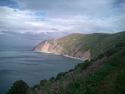
Foreland Point is a rocky headland in Devon near Lynmouth, and is the most northerly point along the Devon and Exmoor coast. The highest cliff is 89 metres (292 ft) above the high tide, although the highest point of the entire headland is near Countisbury (a village around a mile away) at 302 metres (991 ft). The headland is owned by the National Trust; some areas are open to public access all year, as part of the South West Coast Path, while other areas have limited access. The Trinity House-operated Lynmouth Foreland Lighthouse is also located here.
The area of the sea between Bideford and Foreland Point is a Marine Conservation Zone.
References
- "Foreland, North and South" . Encyclopædia Britannica (11th ed.). 1911.
- "Walk - Foreland Point Adventurous Walk". South West Coast Path. Retrieved 27 September 2016.
- "Lynmouth Foreland Lighthouse". Trinity House. Retrieved 27 September 2016.
- "Marine Conservation Zones: Bideford to Foreland Point". Department for Environment, Food & Rural Affairs and Natural England and Joint Nature Conservation Committee. Retrieved 27 September 2016.
51°14′N 3°47′W / 51.233°N 3.783°W / 51.233; -3.783
This Devon location article is a stub. You can help Misplaced Pages by expanding it. |