Unincorporated community in Colorado, United States
| Foxton, Colorado | |
|---|---|
| Unincorporated community | |
  | |
| Coordinates: 39°25′28″N 105°14′10″W / 39.42444°N 105.23611°W / 39.42444; -105.23611 | |
| Country | |
| State | |
| Counties | Jefferson |
| Elevation | 6,460 ft (1,969 m) |
| Time zone | UTC-7 (MST) |
| • Summer (DST) | UTC-6 (MDT) |
| ZIP code | 80433 (Conifer) |
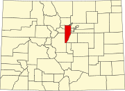
Foxton is an unincorporated community in Jefferson County, Colorado, United States. The U.S. Post Office at Conifer (ZIP Code 80433) now serves Foxton postal addresses.
Geography
Foxton is located at 39°25′28″N 105°14′10″W / 39.42444°N 105.23611°W / 39.42444; -105.23611 (39.4244333, -105.2361032).
References
- ^ "Foxton". Geographic Names Information System. United States Geological Survey, United States Department of the Interior.
- ^ "ZIP Code Lookup". United States Postal Service. January 3, 2007. Archived from the original (JavaScript/HTML) on November 22, 2010. Retrieved January 3, 2007.
| Municipalities and communities of Jefferson County, Colorado, United States | ||
|---|---|---|
| County seat: Golden | ||
| Cities |  | |
| Towns | ||
| CDPs | ||
| Unincorporated communities | ||
| Ghost towns | ||
| Footnotes | ‡This populated place also has portions in an adjacent county or counties | |