| |
|---|---|
| Settlement | |
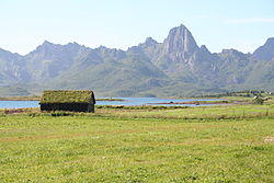
 Frøskeland with Mount Reka in the background Frøskeland with Mount Reka in the background | |
  | |
| Coordinates: 68°45′31″N 15°06′56″E / 68.7585°N 15.1155°E / 68.7585; 15.1155 | |
| Country | Norway |
| Region | Northern Norway |
| County | Nordland |
| District | Vesterålen |
| Municipality | Sortland Municipality |
| Elevation | 9 m (30 ft) |
| Time zone | UTC+01:00 (CET) |
| • Summer (DST) | UTC+02:00 (CEST) |
| Post Code | 8400 Sortland |
Frøskeland (Norwegian) or Froská (Northern Sami) is a village in Sortland Municipality in Nordland county, Norway.
Geography
Frøskeland lies on the island of Langøya, at the innermost part of Eidsfjorden, on the west side of the Vikeid isthmus. County Road 820 from the town of Sortland to Bø Municipality passes through Frøskeland. County Road 821 to the village of Myre branches off from County Road 820 at Frøskeland and travels north across Frøskelandseid (the Frøskeland Isthmus) to Steinlandsfjord in Øksnes Municipality. Frøskeland is also the junction for County Road 885, which travels south along the east side of the Eidsfjorden to the villages of Holmstad, Sandnes, and the Hadsel Bridge.
Name
The name Frøskeland is believed to derive from the word frøskja, related to the verb fryse which means 'freeze'.
Industry and services
The concrete factory Vesterålsbetong AS (formerly Tingvoll Betong AS and SE Betong AS) is located in Frøskeland. Frøskeland had a post office until June 1, 1997.
References
- "Frøskeland, Sortland (Nordland)". yr.no. Retrieved 2018-12-31.
- "Informasjon om stadnamn". Norgeskart (in Norwegian). Kartverket. Retrieved 2024-08-18.
- Vegliste 2016: Fylkes- og kommunale veger. Nordland. 2016. Bodø: Statens vegvesen Region nord, pp. 2ff., 44ff. Archived 2017-03-08 at the Wayback Machine
- Borgos, Johan. 2007. Sortland bygdebok, gård og slekt, part 3. Sortland: Sortland kommune. ISBN 978-82-991889-6-8.
- Vesterålsbetong AS website.
- KulturNav: 8420 Frøskeland (Poståpneri).