Village municipality in New Brunswick, Canada
| Fundy Albert | |
|---|---|
| village municipality | |
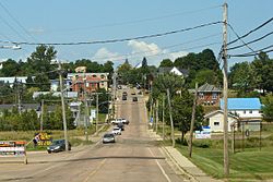
 Hillsborough, NB Main Street (Route 114) looking north Hillsborough, NB Main Street (Route 114) looking north | |
| Country | Canada |
| Province | New Brunswick |
| County | Albert |
| Regional service commission | Southeast |
| Incorporated | January 1, 2023 |
| Government | |
| • Type | district municipal council |
| • Mayor | Robert Rochon |
| Electoral districts | |
| • Federal | Fundy Royal |
| • Provincial | Albert |
| Time zone | UTC-4 (AST) |
| • Summer (DST) | UTC-3 (ADT) |
| Postal code(s) | E4H |
| Area code(s) | 428, 506 |
| Highway | |
Fundy Albert is a village municipality in the Canadian province of New Brunswick. The jurisdiction was formed through the 2023 New Brunswick local governance reforms which saw the consolidation of local government entities into regions or districts.
History
Fundy Albert was established on January 1, 2023 by New Brunswick regulation 2022-50, the Local Governments Establishment Regulation of the Local Governance act, through the amalgamation of the village municipalities of Alma, Riverside-Albert and Hillsborough while at the same time annexing certain mostly adjacent unincorporated areas.
Places of note

- Fundy Albert is home to the Albert County Chamber of Commerce and the historic New Brunswick Railway Museum and the Hon. William Henry Steeves House Museum.
- Grays Island is a cemetery.
- Surrey was amalgamated into Fundy Albert.
- A monument on the Fundy Albert main street marks the Battle of Peticodiac.
Education
Notable people
Main article: List of people from Albert County, New Brunswick- William Steeves, one of the Fathers of Confederation
- Hugh McMonagle, politician
- William James Lewis, politician
- Neil McNeil, former Catholic archbishop of Toronto, was a native of Hillsborough.
- Burpee L. Steeves Lieutenant Governor of Idaho
- Abner Reid McClelan, politician
- Roscoe Fillmore, horticulturalist and activist
- Molly Kool, Master Mariner
Images
See also
- 2023 New Brunswick local governance reform
- List of communities in New Brunswick
- List of municipalities in New Brunswick
References
- Local Governments Establishment Regulation, NB Reg 2022-50, <https://canlii.ca/t/55xk3> retrieved on 2024-02-07
- "Local Governments Establishment Regulation – Local Governance Act". Government of New Brunswick. August 30, 2022. Retrieved January 15, 2023.
- New Brunswick Railway Museum website
| Subdivisions of New Brunswick | |
|---|---|
| Cities | |
| Towns |
|
| Villages | |
| Regional municipality | |
| Rural communities | |
| Rural districts |
|
| Regional service commissions | |
| School districts | |
| Indian reserves |
|
| Non-administrative divisions | |
This New Brunswick location article is a stub. You can help Misplaced Pages by expanding it. |


