| Góra | |
|---|---|
| Village | |
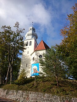
 Saint Matthew Church in Góra Saint Matthew Church in Góra | |
 | |
| Coordinates: 54°37′53″N 18°6′47″E / 54.63139°N 18.11306°E / 54.63139; 18.11306 | |
| Country | |
| Voivodeship | Pomeranian |
| County | Wejherowo |
| Gmina | Wejherowo |
| Population | 628 |
| Time zone | UTC+1 (CET) |
| • Summer (DST) | UTC+2 (CEST) |
| Vehicle registration | GWE |
Góra is a village in the administrative district of Gmina Wejherowo, within Wejherowo County, Pomeranian Voivodeship, in northern Poland. It lies approximately 10 kilometres (6 mi) west of Wejherowo and 45 km (28 mi) north-west of the regional capital Gdańsk. It is located within the ethnocultural region of Kashubia in the historic region of Pomerania.
Góra was a royal village of the Polish Crown, administratively located in the Puck County in the Pomeranian Voivodeship.
References
- "Central Statistical Office (GUS) - TERYT (National Register of Territorial Land Apportionment Journal)" (in Polish). 2008-06-01.
- Biskup, Marian; Tomczak, Andrzej (1955). Mapy województwa pomorskiego w drugiej połowie XVI w. (in Polish). Toruń. p. 100.
{{cite book}}: CS1 maint: location missing publisher (link)
This Wejherowo County location article is a stub. You can help Misplaced Pages by expanding it. |
