| This article contains translated text and the factual accuracy of the translation should be checked by someone fluent in Polish and English. |
| Mount Saint Anne | |
|---|---|
| Annaberg | |
 Góra Świętej Anny seen from Krzeszów Góra Świętej Anny seen from Krzeszów | |
| Highest point | |
| Elevation | 593 m (1,946 ft) |
| Coordinates | 50°44′02″N 16°05′33″E / 50.73389°N 16.09250°E / 50.73389; 16.09250 |
| Geography | |
 | |
| Parent range | Krzeszowskie Wzgórza |
Mount Saint Anne (Polish: Góra Świętej Anny (Krzeszowskie Wzgórza) ; German: Annen Berg, Annaberg) – peak 593 m a.s.l. is a mountain in Poland. located in north-west part of Krzeszowskie Wzgórza, near Kamiengorian Valley (pl. Kotlina Kamiennogórska), in Central Sudeten (pl. Sudety Środkowe).
Geology

The summits are made up of old, upper cretaceous sandstone, glauconite and mud stones. Coming down towards the north side are sandstone and conglomerates of rot legend.
Vegetation
The apex, as well as the majority of bands are covered with pine forest and west stretch meadows.
Chapel of Saint Anne
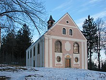
Below the summit, on the western side the mountain lies a baroque chapel of St. Anna dating to 1623. The chapel was destroyed in the second half of the twentieth century, however the inhabitants of Krzeszów rebuilt the chapel in the second decade of the twenty-first century.
Sources
- Marek Staffa (1997). Słownik geografii turystycznej Sudetów, tom 8, Kotlina Kamiennogórska, Wzgórza Bramy Lubawskiej, Zawory. Wrocław: Wydawnictwo I-BiS. pp. 106, 107. ISBN 83-85773-23-1.
- Sudety Środkowe. Skala 1:40000. Jelenia Góra: Wydawnictwo Turystyczne Plan. 2005. ISBN 83-60044-44-9.
References
- "Odbudowali w czynie społecznym kościół - Nasze Sudety". www.naszesudety.pl. Retrieved 2016-04-23.