| Gander | |
|---|---|
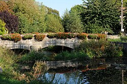
 The Gander in Altwies The Gander in Altwies | |
  | |
| Location | |
| Countries | Luxembourg and France |
| Physical characteristics | |
| Source | |
| • location | Southern Luxembourg |
| Mouth | |
| • location | Moselle |
| • coordinates | 49°26′56″N 6°19′37″E / 49.44889°N 6.32694°E / 49.44889; 6.32694 |
| Basin features | |
| Progression | Moselle→ Rhine→ North Sea |
The Gander (in French, Altbach in Luxembourguish) is a river that flows in Luxembourg and in the French département Moselle, a tributary of the river Moselle (left side). It is about 20 km (12 mi) long, of which 17 km is in France and on the French-Luxembourgish border. Its source is in the commune of Frisange, southern Luxembourg. It flows generally southeast, and from Altwies until Emerange (commune of Burmerange) it forms the French-Luxembourgish border. From Emerange until its outflow into the Moselle at Haute-Kontz, it flows through France. The largest town on the Gander is Mondorf-les-Bains.
References
| Tributaries of the river Moselle | ||
|---|---|---|
| From the left | ||
| From the right | ||
This article related to a river in France is a stub. You can help Misplaced Pages by expanding it. |
This Moselle geographical article is a stub. You can help Misplaced Pages by expanding it. |
This article related to a river in Luxembourg is a stub. You can help Misplaced Pages by expanding it. |