| Gaspar Hernández | |
|---|---|
 | |
 | |
| Coordinates: 19°37′12″N 70°16′48″W / 19.62000°N 70.28000°W / 19.62000; -70.28000 | |
| Country | |
| Province | Espaillat |
| Municipality since | 1907 |
| Area | |
| • Total | 366.18 km (141.38 sq mi) |
| Elevation | 10 m (30 ft) |
| Population | |
| • Total | 57,302 |
| • Density | 160/km (410/sq mi) |
| • Urban | 37,852 |
| Distance to – Moca | 64 km |
| Municipalities | 3 |
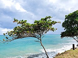
Gaspar Hernández is a small city in Espaillat province on the North Coast Dominican Republic.
Gaspar Hernandez is a very typical Dominican town, although it is somewhat, indirectly dependent on tourism, its main base of income is cattle and agriculture.
Famous Dominican baseball coach and trainer Ramon Lora (born 1977), now coaching at Western Oklahoma State College, was born in Gaspar Hernandez. Lora's 2011 team captured the NJCAA National Championship while featuring numerous Dominican players at the American college.
History
The current site of Gaspar Hernandez retains features of indigenous culture, mainly of the Ciguayo and Ciboney Indians from the societies of Río San Juan, Nagua and Samana.
The present municipality was founded on April 5, 1907, in a place originally called Canto La Ermita. At that time the population was concentrated on the banks of the river Joba. The place was renamed Gaspar Hernández in honor of the famous priest, associate of Juan Pablo Duarte in the war of independence from Haiti.
Climate
| Climate data for Gaspar Hernández (1961–1990) | |||||||||||||
|---|---|---|---|---|---|---|---|---|---|---|---|---|---|
| Month | Jan | Feb | Mar | Apr | May | Jun | Jul | Aug | Sep | Oct | Nov | Dec | Year |
| Record high °C (°F) | 34.0 (93.2) |
34.0 (93.2) |
35.8 (96.4) |
35.4 (95.7) |
37.8 (100.0) |
38.0 (100.4) |
36.6 (97.9) |
38.9 (102.0) |
37.0 (98.6) |
38.0 (100.4) |
38.7 (101.7) |
34.8 (94.6) |
38.9 (102.0) |
| Mean daily maximum °C (°F) | 27.4 (81.3) |
27.9 (82.2) |
28.7 (83.7) |
29.2 (84.6) |
30.6 (87.1) |
32.0 (89.6) |
31.7 (89.1) |
31.6 (88.9) |
31.6 (88.9) |
31.2 (88.2) |
29.2 (84.6) |
27.3 (81.1) |
29.9 (85.8) |
| Mean daily minimum °C (°F) | 18.9 (66.0) |
18.8 (65.8) |
19.4 (66.9) |
19.9 (67.8) |
20.9 (69.6) |
22.3 (72.1) |
22.3 (72.1) |
21.9 (71.4) |
21.8 (71.2) |
21.9 (71.4) |
20.6 (69.1) |
19.5 (67.1) |
20.7 (69.3) |
| Record low °C (°F) | 11.0 (51.8) |
12.0 (53.6) |
12.9 (55.2) |
14.8 (58.6) |
12.0 (53.6) |
18.0 (64.4) |
16.0 (60.8) |
11.0 (51.8) |
11.6 (52.9) |
18.0 (64.4) |
11.0 (51.8) |
11.0 (51.8) |
11.0 (51.8) |
| Average rainfall mm (inches) | 164.8 (6.49) |
130.3 (5.13) |
150.4 (5.92) |
192.2 (7.57) |
198.8 (7.83) |
106.9 (4.21) |
121.3 (4.78) |
129.0 (5.08) |
99.4 (3.91) |
159.2 (6.27) |
310.5 (12.22) |
273.2 (10.76) |
2,036 (80.16) |
| Average rainy days (≥ 1.0 mm) | 11.0 | 8.0 | 8.6 | 8.4 | 10.5 | 6.7 | 9.9 | 10.5 | 7.1 | 9.1 | 14.8 | 14.3 | 118.9 |
| Source: NOAA | |||||||||||||
Economy
The municipality of Gaspar Hernandez has a diversified economy divided between tourism and agricultural production.
Ecotourism exists mainly in the Ojo de Agua district, with caves and caverns, beautiful natural landscapes, and the source of water, dipping between rocks and reappearing as the Ojo de Agua. Important hotel projects along the coast of Gaspar Hernandez include: Bahia Principe, Bahia Esmeralda, El Pescador, Playa Cana, Playa Rogelio, and Punta Gorda .
The Municipal District of Veragua produces banana, maize, cassava, and sweet potatoes. The District of Joba Arriba is the largest producer of cocoa, with one of the country's largest cocoa farmers' associations. It also produces other minor agricultural products. Cattle and hogs are another important sector.
Fishing has developed gradually, catering to the tourist resorts of Sosua and Cabarete. Beekeeping is a new activity in the municipality in the production of honey, pollen and Royal Jelly.
References
- Superficies a nivel de municipios, Oficina Nacional de Estadistica Archived April 17, 2009, at the Wayback Machine
- De la Fuente, Santiago (1976). Geografía Dominicana (in Spanish). Santo Domingo, Dominican Republic: Editora Colegial Quisqueyana.
- Censo 2012 de Población y Vivienda, Oficina Nacional de Estadistica
- "Gaspar Hdez. Climate Normals 1961-1990". National Oceanic and Atmospheric Administration. Retrieved September 12, 2016.
Sources
- World Gazeteer: Dominican Republic – World-Gazetteer.com
- https://web.archive.org/web/20120701190007/http://www.quisqueyavirtual.edu.do/Municipio_Gaspar_Hern%C3%A1ndez