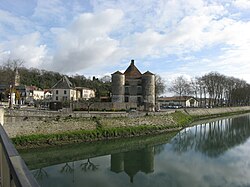
| Gaves réunis | |
|---|---|
 | |
  | |
| Location | |
| Country | France |
| Physical characteristics | |
| Source | |
| • location | Peyrehorade |
| Mouth | |
| • location | Adour |
| • coordinates | 43°32′46″N 1°11′41″W / 43.54611°N 1.19472°W / 43.54611; -1.19472 |
| Length | 9.4 km (5.8 mi) |
| Basin size | 5,200 km (2,000 sq mi) |
| Discharge | |
| • average | 188 m/s (6,600 cu ft/s) |
| Basin features | |
| Progression | Adour→ Atlantic Ocean |
The Gaves réunis (French pronunciation: [ɡav ʁeyni]) is a 9.4 km river in southwestern France connecting Peyrehorade to the Adour at Bec du Gave. It is formed by the confluence of the Gave de Pau and the Gave d'Oloron. It is navigable for 8 km from the confluence with the Adour until the town Peyrehorade.
See also
References
- McKnight, Hugh (2005). Cruising French Waterways, 4th Edition. Sheridan House. ISBN 9781574092103.
- Fluviacarte, Gaves réunis
This article related to a river in France is a stub. You can help Misplaced Pages by expanding it. |