| This article relies largely or entirely on a single source. Relevant discussion may be found on the talk page. Please help improve this article by introducing citations to additional sources. Find sources: "Gê'gyai County" – news · newspapers · books · scholar · JSTOR (October 2020) |
| Gê'gyai County 革吉县 • དགེ་རྒྱས་རྫོང་། | |
|---|---|
| County | |
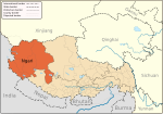
 Location of Gê'gyai County (red) within Ngari Prefecture (yellow) and the Tibet Autonomous Region Location of Gê'gyai County (red) within Ngari Prefecture (yellow) and the Tibet Autonomous Region | |
   | |
| Coordinates: 31°57′21″N 81°56′53″E / 31.95583°N 81.94806°E / 31.95583; 81.94806 | |
| Country | China |
| Autonomous region | Tibet |
| Prefecture | Ngari |
| County seat | Gê'gyai |
| Area | |
| • Total | 46,104.28 km (17,800.96 sq mi) |
| Population | |
| • Total | 18,012 |
| • Density | 0.39/km (1.0/sq mi) |
| Time zone | UTC+8 (China Standard) |
| Website | gj |
| Gê'gyai County | |||||||
|---|---|---|---|---|---|---|---|
| Chinese name | |||||||
| Simplified Chinese | 革吉县 | ||||||
| Traditional Chinese | 革吉縣 | ||||||
| |||||||
| Tibetan name | |||||||
| Tibetan | དགེ་རྒྱས་རྫོང་། | ||||||
| |||||||
Gê'gyai County (Tibetan: དགེ་རྒྱས་རྫོང་།, Chinese: 革吉县) is a county in Ngari Prefecture of the Tibet Autonomous Region, China. 'Gê'gyai' is Tibetan for "full beauty".
Administrative divisions
Gê'gyai county is divided into 1 town and 4 townships:
| Name | Chinese | Hanyu Pinyin | Tibetan | Wylie |
|---|---|---|---|---|
| Town | ||||
| Gê'gyai Town | 革吉镇 | Géjí zhèn | དགེ་རྒྱས་གྲོང་རྡལ། | dge rgyas grong rdal |
| Townships | ||||
| Zhungpa Township | 雄巴乡 | Xióngbā xiāng | གཞུང་པ་ཤང་། | gzhung pa shang |
| Yagra Township | 亚热乡 | Yàrè xiāng | ཡག་རྭ་ཤང་། | yag rwa shang |
| Chaco Township (Yanhu) |
盐湖乡 | Yánhú xiāng | ཚྭ་མཚོ་ཤང་། | tshwa mtsho shang |
| Wönpo Tamzang Township | 文布当桑乡 | Wénbùdāngsāng xiāng | བོན་པོ་གཏམ་བཟང་ཤང་། | bon po gtam bzang shang |
Demography
Population of this district was 12,313 inhabitants in 1999.
References
- "阿里地区第七次全国人口普查主要数据公报" (in Chinese). Administrative Commission of Ngari Prefecture. 2021-06-10. Archived from the original on 2022-06-11. Retrieved 2023-08-19.
- National Population Statistics Materials by County and City - 1999 Period, in China County & City Population 1999, Harvard China Historical GIS
| County-level divisions of Tibet Autonomous Region | |||||||||||||
|---|---|---|---|---|---|---|---|---|---|---|---|---|---|
| Lhasa (capital) | |||||||||||||
| Prefecture-level cities |
| ||||||||||||
| Prefecture |
| ||||||||||||
| ** Southern portions of these counties are claimed by the People's Republic of China as part of the South Tibet area, but are administered by India. | |||||||||||||
| Ngari Prefecture, Tibet | ||
|---|---|---|
| County-level divisions |  | |
| Towns and villages | ||
| Geography | ||
| Landmarks | ||
| Sciences | ||
This Ngari Prefecture, Tibet location article is a stub. You can help Misplaced Pages by expanding it. |