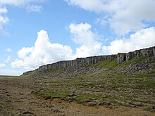

Gerðuberg (Icelandic pronunciation: [ˈcɛrðʏˌpɛrk]; also transcribed Gerduberg) is a cliff of dolerite, a coarse-grained basalt rock, located on western peninsula Snæfellsnes and on the western edge of the Hnappadalur [ˈn̥ahpaˌtaːlʏr̥] valley, 46 km in the north of the town of Borgarnes and 115 km to Reykjavík.
Gerðuberg was formed from flowing basaltic lava, cooled by the sea, solidified in very evenly running columns. These are between 1 and 1.5 m wide and 7 to 14 m high.
Near Gerðuberg
- Volcanic cone Eldborg
- a water source
- Löngufjörur [ˈlœyŋkʏˌfjœːrʏr̥] beach
- settlement Borg á Mýrum
References
- "Place". Archived from the original on 2014-02-20. Retrieved 2014-01-26.
{{cite web}}: CS1 maint: bot: original URL status unknown (link) - "Klifur.is - Gerðuberg". Archived from the original on 2014-02-01. Retrieved 2012-09-05.
{{cite web}}: CS1 maint: bot: original URL status unknown (link)
See also
64°51′39″N 22°21′41″W / 64.860699°N 22.36139°W / 64.860699; -22.36139
Categories: