| Gillsvannet | |
|---|---|
| Gillsvann Gjelsvatnet | |
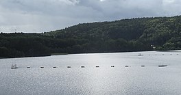
 View of the lake View of the lake | |
  | |
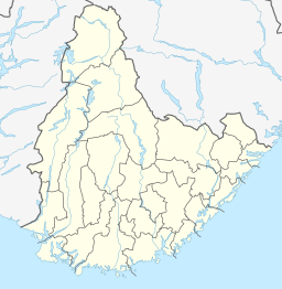
| Location | Kristiansand, Agder |
| Coordinates | 58°11′15″N 8°01′24″E / 58.1874°N 08.0234°E / 58.1874; 08.0234 |
| Primary outflows | Topdalsfjorden |
| Basin countries | Norway |
| Max. length | 1.9 kilometres (1.2 mi) |
| Max. width | 1.5 kilometres (0.93 mi) |
| Surface area | 1.05 km (0.41 sq mi) |
| Surface elevation | 1 metre (3 ft 3 in) |
| References | NVE |
Gillsvannet or Gjelsvannet is a freshwater lake in the municipality of Kristiansand in Agder county, Norway. The 1.05-square-kilometre (260-acre) lake is located about 5 kilometres (3.1 mi) northeast of downtown Kristiansand, along to County Road 452. The lake lies about 300 metres (980 ft) west of the Topdalsfjorden, at an elevation of about 1 metre (3 ft 3 in) above sea level. There is a practice range for kayaking on the lake as well as many areas used for swimming during the summer season. The Gimlekollen district lies on the southern shore of the lake and the village of Justvik lies just north of the lake.
See also
References
- "Gillsvannet, Kristiansand (Agder)" (in Norwegian). yr.no. Retrieved 2017-02-10.
- "Om flattvannsgruppa" (in Norwegian). Kristiansand kajakklubb. Archived from the original on 2015-10-12. Retrieved 2017-02-10.
External links
- Kristiansand Gillsvannet Archived 2015-10-12 at the Wayback Machine Kristiansand Kajakk Klubb (in Norwegian)