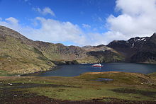

Godthul (Spanish: Buen Arroyo) is a bay 1 mile (1.6 km) long entered between Cape George and Long Point, on the east side of Barff Peninsula on the north coast of South Georgia Island. It sits between Rookery Bay to the north and Johannsen Loch to the south. Szielasko Ice Cap sits on the south edge of the harbor. The name Godthul (Norwegian for "Good Hollow") dates back to the period 1905–12, and was probably applied by Norwegian sealers and whalers working in the area.
Godthul was used as a whaling station between 1908 and 1929. It had basic infrastructure supported by factory ships, but no land station.
References
- "Godthul". Geographic Names Information System. United States Geological Survey. Retrieved 13 May 2019.
- "Whaling Stations - Godthul". Government of South Georgia & the South Sandwich Islands. Retrieved 13 May 2019.
- Hart, Ian B. (2006). Whaling in the Falkland Islands Dependencies 1904-1931: A History of Shore and Bay-based Whaling in the Antarctic. Pequena. p. 66. Retrieved 13 May 2019.
54°17′S 36°18′W / 54.283°S 36.300°W / -54.283; -36.300
| Capital: King Edward Point | |||||||
| General | |||||||
| Settlements / Whaling stations | |||||||
| South Georgia islands | |||||||
| South Sandwich Islands |
| ||||||
| Seamounts | |||||||
| Landmarks |
| ||||||
This South Georgia and the South Sandwich Islands location article is a stub. You can help Misplaced Pages by expanding it. |