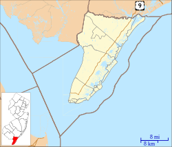
Census-designated place in New Jersey, United States
| Goshen, New Jersey | |
|---|---|
| Census-designated place | |
 Sign stating the community's name Sign stating the community's name | |
   | |
| Coordinates: 39°08′29″N 74°51′11″W / 39.14139°N 74.85306°W / 39.14139; -74.85306 | |
| Country | |
| State | |
| County | Cape May |
| Township | Middle |
| Area | |
| • Total | 1.75 sq mi (4.53 km) |
| • Land | 1.75 sq mi (4.52 km) |
| • Water | 0.00 sq mi (0.01 km) |
| Elevation | 10 ft (3 m) |
| Population | |
| • Total | 400 |
| • Density | 229.10/sq mi (88.47/km) |
| ZIP Code | 08210 |
| FIPS code | 34-27030 |
| GNIS feature ID | 0876685 |
Goshen is an unincorporated community and census-designated place (CDP) located within Middle Township, in Cape May County, in the U.S. state of New Jersey.
Route 47, also known as Delsea Drive, runs directly through the center of the community.
History


The area was settled by Aaron Leaming, who began raising cattle in 1693. By 1710 there was a settlement. Goshen's first industry was a king crab mill and a canning factory. Shipbuilding and lumbering industries flourished. A post office was established in 1818, with Richard Thompson Jr. as the first postmaster.
The Garrison shipyard on Goshen Creek had stocks for the simultaneous construction of two vessels, which, upon being launched, were slipped into the water sideways. Between 1859 and 1898, twenty-five ships of record were built there, along with many smaller craft. Around 1900, Cape May County's shipbuilding industry was shut down. The last ship launched by the Goshen shipyard was the Diamond in 1898. Due to the lasting effects of the brackish water there, the remains of the docks are still visible at the end of Goshen Landing Road during low tide.
The Tavern House (circa 1725), on the corner of Route 47 and Goshen Landing Road, is one of the oldest homes in Cape May County. At different times it has been a tavern, hotel, dentist office and residence. While significant changes have been made, much of the original workmanship is still evident. Rough-hewn logs still support the house, and wooden pegs hold the rafters in place.
Demographics
As of the 2020 United States census, the area had a population of 400.
| Census | Pop. | Note | %± |
|---|---|---|---|
| 2020 | 400 | — | |
| U.S. Decennial Census 2020 | |||
Education
Residents of Goshen attend the Middle Township Public Schools, which operates Middle Township High School.
Countywide schools include Cape May County Technical High School and Cape May County Special Services School District.
Notable people
See also: Category:People from Middle Township, New JerseyPeople who were born in, residents of, or otherwise closely associated with Goshen include:
- Andrew J. Tomlin (1845–1906), awarded the Medal of Honor for his actions in the Civil War.
Wineries
References
- "ArcGIS REST Services Directory". United States Census Bureau. Retrieved October 11, 2022.
- ^ Census Data Explorer: Goshen CDP, New Jersey, United States Census Bureau. Accessed June 15, 2023.
- Geographic Codes Lookup for New Jersey, Missouri Census Data Center. Accessed June 9, 2023.
- "Goshen". Geographic Names Information System. United States Geological Survey, United States Department of the Interior. Retrieved October 6, 2012.
- State of New Jersey Census Designated Places - BVP20 - Data as of January 1, 2020, United States Census Bureau. Accessed December 1, 2022.
- Locality Search, State of New Jersey. Accessed June 9, 2016.
- Stevens, Lewis Townsend (1897). The History of Cape May County, New Jersey: From the Aboriginal Times to the Present Day. Star of the Cape Publishing Co. p. 466.
- "Census of Population and Housing". Census.gov. Retrieved June 4, 2016.
- "2020 CENSUS - SCHOOL DISTRICT REFERENCE MAP: Cape May County, NJ" (PDF). United States Census Bureau. Retrieved April 8, 2024.
- Frequently Asked Questions Archived October 27, 2019, at the Wayback Machine, Cape May County Technical High School. Accessed October 27, 2019. "All residents of Cape May County are eligible to attend Cape May County Technical High School.... The Cape May County Technical High School is a public school so there is no cost to residents of Cape May County."
- Technical High School Admissions Archived October 27, 2019, at the Wayback Machine, Cape May County Technical High School. Accessed October 27, 2019. "All students who are residents of Cape May County may apply to the Technical High School."
- Andrew J. Tomlin, Congressional Medal of Honor Society of the United States of America. Accessed July 9, 2013.
| Middle Township, New Jersey | |
|---|---|
| Settlements | |
| Education | |
| Landmarks | |
| Media | |
| This list is incomplete. Formerly Whitesboro and Burleigh were in a single CDP, Whitesboro-Burleigh Cape May County Airport (The former NAS Rio Grande) is in Lower Township. Dennis Township Public Schools has a Cape May Court House address but is in Dennis Township, outside of the CMCH census-designated place. | |
| Municipalities and communities of Cape May County, New Jersey, United States | ||
|---|---|---|
| County seat: Cape May Court House | ||
| Cities |  | |
| Boroughs | ||
| Townships | ||
| CDPs | ||
| Other communities | ||