| This article uses bare URLs, which are uninformative and vulnerable to link rot. Please consider converting them to full citations to ensure the article remains verifiable and maintains a consistent citation style. Several templates and tools are available to assist in formatting, such as reFill (documentation) and Citation bot (documentation). (August 2022) (Learn how and when to remove this message) |
| Guaranda, Sucre | |
|---|---|
| Municipality and town | |
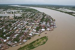
 View of Guaranda View of Guaranda | |
 Flag Flag Seal Seal | |
 Location of the municipality and town of Guaranda, Sucre in the Sucre Department of Colombia. Location of the municipality and town of Guaranda, Sucre in the Sucre Department of Colombia. | |
| Country | |
| Department | Sucre Department |
| Area | |
| • Total | 354 km (137 sq mi) |
| Population | |
| • Total | 15,618 |
| • Density | 44/km (110/sq mi) |
| Time zone | UTC-5 (Colombia Standard Time) |
Guaranda is a town and municipality located in the Sucre Department, northern Colombia.
Climate
Guaranda has a tropical monsoon climate (Am) with heavy rainfall in all months except January.
| Climate data for Guaranda | |||||||||||||
|---|---|---|---|---|---|---|---|---|---|---|---|---|---|
| Month | Jan | Feb | Mar | Apr | May | Jun | Jul | Aug | Sep | Oct | Nov | Dec | Year |
| Mean daily maximum °C (°F) | 32.5 (90.5) |
33.2 (91.8) |
33.3 (91.9) |
33.1 (91.6) |
32.1 (89.8) |
32.0 (89.6) |
32.2 (90.0) |
32.0 (89.6) |
31.7 (89.1) |
31.4 (88.5) |
31.6 (88.9) |
32.0 (89.6) |
32.3 (90.1) |
| Daily mean °C (°F) | 27.7 (81.9) |
28.1 (82.6) |
28.5 (83.3) |
28.5 (83.3) |
27.8 (82.0) |
27.9 (82.2) |
27.7 (81.9) |
27.7 (81.9) |
27.3 (81.1) |
27.2 (81.0) |
27.6 (81.7) |
27.6 (81.7) |
27.8 (82.1) |
| Mean daily minimum °C (°F) | 23.0 (73.4) |
23.1 (73.6) |
23.7 (74.7) |
23.9 (75.0) |
23.6 (74.5) |
23.8 (74.8) |
23.2 (73.8) |
23.4 (74.1) |
23.0 (73.4) |
23.1 (73.6) |
23.6 (74.5) |
23.3 (73.9) |
23.4 (74.1) |
| Average rainfall mm (inches) | 0.8 (0.03) |
70.8 (2.79) |
100.5 (3.96) |
230.2 (9.06) |
444.6 (17.50) |
446.7 (17.59) |
482.8 (19.01) |
439.3 (17.30) |
374.7 (14.75) |
440.9 (17.36) |
295.6 (11.64) |
159.7 (6.29) |
3,486.6 (137.28) |
| Average rainy days | 2 | 3 | 3 | 8 | 12 | 12 | 13 | 14 | 12 | 13 | 11 | 6 | 109 |
| Source: | |||||||||||||
References
- (in Spanish) Gobernacion de Sucre - Guaranda
- (in Spanish) Guaranda official website Archived 2021-01-19 at the Wayback Machine
- "Censo Nacional de Población y Vivienda 2018" (in Spanish). DANE. Archived from the original on 13 August 2020. Retrieved 25 April 2020.
- http://www.ideam.gov.co/documents/21021/553571/Promedios+Climatol%C3%B3gicos++1981+-+2010.xlsx/f28d0b07-1208-4a46-8ccf-bddd70fb4128
| Municipalities in Sucre Department | ||
|---|---|---|
8°28′N 75°32′W / 8.467°N 75.533°W / 8.467; -75.533
This Sucre Department location article is a stub. You can help Misplaced Pages by expanding it. |