| Guarenas-Guatire conurbation (Guarenas-Guatire Metropolitan Area) Conurbación Guarenas-Guatire Area Metropolitana de Guarenas-Guatire | |
|---|---|
| Conurbation | |
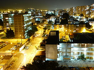
 27 de Febrero neighborhood in Guarenas 27 de Febrero neighborhood in Guarenas | |
| Country | |
| State | |
| Largest Cities | Guarenas Guatire |
| Area | |
| • Metro | 558 km (215 sq mi) |
| Population | |
| • Metro | 488,000 |
| • Metro density | 848.97/km (2,198.8/sq mi) |
| Time zone | UTC-4:30 (VST) |
Guarenas-Guatire conurbation or Guarenas-Guatire metropolitan area (Spanish: Conurbación Guarenas-Guatire or Area Metropolitana de Guarenas-Guatire), also known as El Nuevo Este de Caracas (New East of Caracas), is a conurbation area in Miranda, Venezuela, that includes 2 municipalities, it is part of the Greater Caracas Area. It has a population of approximately 488,000 inhabitants.
Cities
The principal cities of the area are (2013):
Municipalities
The 2 municipalities of the area are:
| Municipality | Area (km) | Population 2013 | Population density 2013 (/km) |
|---|---|---|---|
| Plaza | 180 | 264,290 | 1,468.27 |
| Zamora | 378 | 209,438 | 554.06 |
| Guarenas-Guatire conurbation | 558 | 473,728 | 848.97 |
Transportation
| This article needs to be updated. Please help update this article to reflect recent events or newly available information. (January 2022) |
The Guarenas / Guatire Metro is a dual subway / light rail system project to connect the twin cities and intermediate communities to Caracas.
See also
External links
- Estado Miranda
- guarenasonline.com
- plaza-miranda.gob.ve (in Spanish)
- zamora-miranda.gob.ve (in Spanish)
References
- ^ "Archived copy" (PDF). Archived from the original (PDF) on 2015-09-23. Retrieved 2014-10-19.
{{cite web}}: CS1 maint: archived copy as title (link) - http://www.miranda.gov.ve/index.php?option=com_content&view=article&id=1100&Itemid=238 Archived 2016-03-04 at the Wayback Machine "Conurbación Guarenas-Guatire"
- http://geodeg.com/search.php?q=miranda&language=&country=229&n=500 Conurbación Guatire-Guarenas
- Oropeza, Mónica; Sáez Sáez, Vidal; Lemús, Jesús; Siso, Eunice; Barrios, Pedro (December 2009). "Riesgos por desbordamientos e inundaciones en la Cuenca del Río Guarenas, estado Miranda, Venezuela" [Overflow and floods risk for flooding in Guarenas River Basin, Miranda state, Venezuela]. Terra (in Spanish). 25 (38): 141–166. hdl:123456789/4989.
La conurbación Guarenas-Guatire-Araira forma parte del área metropolitana de la ciudad de Caracas; representa un conjunto de centros poblados de expansión para el crecimiento urbano e industrial (Díaz, 2005)
- "Archived copy" (PDF). Archived from the original (PDF) on 2014-10-16. Retrieved 2014-10-09.
{{cite web}}: CS1 maint: archived copy as title (link) Conurbación Guarenas-Guatire: constituye una conurbación y como tal un centro regional de segundo orden, cuya forma y estructura están determinadas por la presencia de zonas naturales protegidas, las cuales la limitan y condicionan y constituye una zona de paso de los flujos provenientes de Caracas y que se dirigen a la zona de Barlovento y los estados orientales del país. - "Guarenas-Guatire, Venezuela Population 2024". worldpopulationreview.com. Retrieved 2024-09-27.
- http://www.ine.gob.ve/documentos/see/sintesisestadistica2011/estados/miranda/index.htm Sintesis Estadistica de Miranda: POBLACIÓN
This article related to a location in Miranda, Venezuela is a stub. You can help Misplaced Pages by expanding it. |