| Cavaillon | |
|---|---|
| Commune | |
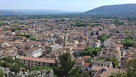
 A view of Cavaillon A view of Cavaillon | |
 Coat of arms Coat of arms | |
| Location of Cavaillon | |
  | |
| Coordinates: 43°50′15″N 5°02′17″E / 43.8375°N 5.0381°E / 43.8375; 5.0381 | |
| Country | France |
| Region | Provence-Alpes-Côte d'Azur |
| Department | Vaucluse |
| Arrondissement | Apt |
| Canton | Cavaillon |
| Intercommunality | CA Luberon Monts de Vaucluse |
| Government | |
| • Mayor (2020–2026) | Gérard Daudet |
| Area | 45.96 km (17.75 sq mi) |
| Population | 25,890 |
| • Density | 560/km (1,500/sq mi) |
| Time zone | UTC+01:00 (CET) |
| • Summer (DST) | UTC+02:00 (CEST) |
| INSEE/Postal code | 84035 /84300 |
| Elevation | 49–200 m (161–656 ft) (avg. 75 m or 246 ft) |
| French Land Register data, which excludes lakes, ponds, glaciers > 1 km (0.386 sq mi or 247 acres) and river estuaries. | |
Cavaillon (French pronunciation: [kavajɔ̃]; Occitan: Cavalhon) is a commune in the Vaucluse department in the Provence-Alpes-Côte d'Azur region of Southeastern France. It is situated in the Durance Valley, at the foot of the Luberon mountains.
History
Cavaillon was already a city in the Gallo-Roman period, and has several minor relics from that era, including a 1st century triumphal arch. Other minor relics of the Roman period have been found to the south of the town, on the site of the ancient Cabellio. It was the seat of the bishops of Cavaillon from the 4th century until the French Revolution. Saint Veran was bishop here in the 6th century, and the 12th-century cathedral is dedicated to him. In the Middle Ages Cavaillon was part of the Comtat Venaissin.
Geography
Cavaillon is part of the Regional and Natural Park of Luberon (parc naturel régional du Luberon) in the French Department of Vaucluse.
The Calavon, a tributary of the Durance locally called Coulon, flows westward through the middle of the commune.
The Durance forms the commune's south-western border.
Population
|
| ||||||||||||||||||||||||||||||||||||||||||||||||||||||||||||||||||||||||||||||||||||||||||||||||||||||||||||||||||
| |||||||||||||||||||||||||||||||||||||||||||||||||||||||||||||||||||||||||||||||||||||||||||||||||||||||||||||||||||
| Source: EHESS and INSEE (1968-2020) | |||||||||||||||||||||||||||||||||||||||||||||||||||||||||||||||||||||||||||||||||||||||||||||||||||||||||||||||||||
Economy
Cavaillon is famous for its melons, as well as other early fruits and vegetables.
Famous people
- Saint César de Bus
- Luc Bulot, French palaeontologist
- Pierre Salinger, press secretary to U.S. President John F. Kennedy, U.S. Senator from California, Paris bureau chief for ABC News
Sights
- the 11th-13th century Cavaillon Cathedral
- Colline Saint-Jacques, with chapel
- Roman triumphal arch
Twin towns
- Cavaillon has been twinned with Weinheim, Germany, since 1958 and Langhirano, Italy, since 2001.
Climate
| Climate data for Cavaillon (1981–2010 normals, extremes 1962–present) | |||||||||||||
|---|---|---|---|---|---|---|---|---|---|---|---|---|---|
| Month | Jan | Feb | Mar | Apr | May | Jun | Jul | Aug | Sep | Oct | Nov | Dec | Year |
| Record high °C (°F) | 20.5 (68.9) |
22.3 (72.1) |
27.1 (80.8) |
29.8 (85.6) |
34.1 (93.4) |
37.5 (99.5) |
39.0 (102.2) |
38.9 (102.0) |
35.0 (95.0) |
29.4 (84.9) |
26.5 (79.7) |
20.3 (68.5) |
39.0 (102.2) |
| Mean daily maximum °C (°F) | 9.9 (49.8) |
11.7 (53.1) |
15.6 (60.1) |
18.6 (65.5) |
23.2 (73.8) |
27.2 (81.0) |
30.5 (86.9) |
29.8 (85.6) |
25.0 (77.0) |
19.9 (67.8) |
13.6 (56.5) |
10.2 (50.4) |
19.6 (67.3) |
| Daily mean °C (°F) | 5.3 (41.5) |
6.6 (43.9) |
9.9 (49.8) |
12.7 (54.9) |
17.0 (62.6) |
20.7 (69.3) |
23.5 (74.3) |
23.0 (73.4) |
19.0 (66.2) |
14.8 (58.6) |
9.1 (48.4) |
5.9 (42.6) |
14.0 (57.2) |
| Mean daily minimum °C (°F) | 0.7 (33.3) |
1.4 (34.5) |
4.2 (39.6) |
6.9 (44.4) |
10.7 (51.3) |
14.2 (57.6) |
16.6 (61.9) |
16.2 (61.2) |
12.9 (55.2) |
9.6 (49.3) |
4.6 (40.3) |
1.6 (34.9) |
8.3 (46.9) |
| Record low °C (°F) | −17.0 (1.4) |
−19.0 (−2.2) |
−11.5 (11.3) |
−2.1 (28.2) |
0.0 (32.0) |
4.0 (39.2) |
7.2 (45.0) |
6.6 (43.9) |
2.0 (35.6) |
−4.2 (24.4) |
−9.2 (15.4) |
−20.0 (−4.0) |
−20.0 (−4.0) |
| Average precipitation mm (inches) | 48.3 (1.90) |
37.5 (1.48) |
38.9 (1.53) |
64.5 (2.54) |
57.7 (2.27) |
34.1 (1.34) |
19.2 (0.76) |
44.3 (1.74) |
96.5 (3.80) |
91.0 (3.58) |
69.4 (2.73) |
51.6 (2.03) |
653.0 (25.71) |
| Average precipitation days (≥ 1.0 mm) | 5.6 | 5.1 | 4.8 | 7.1 | 6.1 | 4.2 | 2.3 | 3.3 | 5.2 | 7.4 | 6.6 | 5.9 | 63.5 |
| Source: Meteociel | |||||||||||||
See also
References
- "Répertoire national des élus: les maires" (in French). data.gouv.fr, Plateforme ouverte des données publiques françaises. 13 September 2022.
- "Populations de référence 2022" (in French). The National Institute of Statistics and Economic Studies. 19 December 2024.
- Commune de Cavaillon (84035), INSEE
- ^ Base Mérimée: Arc antique, Ministère français de la Culture. (in French)
- ^ Chisholm, Hugh, ed. (1911). "Cavaillon" . Encyclopædia Britannica. Vol. 5 (11th ed.). Cambridge University Press. p. 561.
- ^ Base Mérimée: Cathédrale Notre-Dame et Saint-Véran actuellement église paroissiale Saint-Véran, Ministère français de la Culture. (in French)
- Des villages de Cassini aux communes d'aujourd'hui: Commune data sheet Cavaillon, EHESS (in French).
- Population en historique depuis 1968, INSEE
- "Normales et records pour Cavaillon (84)". Meteociel. Retrieved 14 December 2024.