| This article needs additional citations for verification. Please help improve this article by adding citations to reliable sources. Unsourced material may be challenged and removed. Find sources: "Höga Kusten Airport" – news · newspapers · books · scholar · JSTOR (March 2023) (Learn how and when to remove this message) |
| Höga Kusten Airport Kramfors-Sollefteå flygplats | |||||||||||
|---|---|---|---|---|---|---|---|---|---|---|---|
 | |||||||||||
 | |||||||||||
| Summary | |||||||||||
| Airport type | Public and other municipalities | ||||||||||
| Owner | Kramfors Municipality and Sollefteå Municipality | ||||||||||
| Operator | Höga Kusten Airport AB | ||||||||||
| Serves | Kramfors, Sollefteå | ||||||||||
| Location | Nyland, Sweden | ||||||||||
| Elevation AMSL | 10 m / 33 ft | ||||||||||
| Coordinates | 63°02′55″N 017°46′08″E / 63.04861°N 17.76889°E / 63.04861; 17.76889 | ||||||||||
| Website | www.hogakustenairport.se | ||||||||||
| Map | |||||||||||
  | |||||||||||
| Runways | |||||||||||
| |||||||||||
| Statistics (2016) | |||||||||||
| |||||||||||
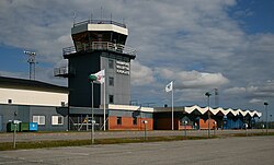
Höga Kusten Airport (IATA: KRF, ICAO: ESNK), translated High Coast Airport, is an airport situated between the localities Kramfors and Sollefteå in Sweden. Its official name according to the Swedish Aeronautical Information Publication is Kramfors-Sollefteå Airport. The airport is named Kramfors on tickets and flight lists on other airports.
History
The number of passengers in 2017 was 11,396, dropping sharply from 62,000 in 2000 and 18,455 in 2012. The reason for this is low price flights from larger airports relatively nearby like Örnsköldsvik Airport and Sundsvall-Timrå Airport and the 5-hour train connection to Stockholm (started 2012) (travel has not been reduced overall during this period, but Kramfors passengers have to a large extent chosen other routes).
Airlines and destinations
The following airlines operate regular scheduled and charter flights at Höga Kusten Airport:
| Airlines | Destinations |
|---|---|
| Amapola Flyg | Gällivare, Stockholm–Arlanda |
Statistics
| Graphs are unavailable due to technical issues. Updates on reimplementing the Graph extension, which will be known as the Chart extension, can be found on Phabricator and on MediaWiki.org. |
Transportation
Ground transport is by taxi, shared taxi, rental car or own car. There is a railway station on the Ådalen Line 1½ km (1 mile) from the airport. Taxi transfer is available, which should be pre-booked.
See also
References
- "Swedish IAIP". AROWeb - AIS MET and Flight Planning. Norrköping: LFV Group - Air Navigation Services of Sweden (Luftfartsverket). Retrieved 9 July 2023.
- ^ "Amapola och Jonair vann upphandlingen". flygtorget.se. Retrieved 1 March 2023.
- "LIST OF PUBLIC SERVICE OBLIGATIONS" (PDF). Aeroroutes.com. 11 March 2024. Retrieved 4 January 2025.
External links
Portals:| Airports in Sweden | |
|---|---|
| Major international | |
| Minor international | |
| Domestic | |
| Unscheduled | |
| see also: List of airports · Swedavia · Civil Aviation Administration · List of the busiest airports in the Nordic countries | |
This article about an airport in Sweden is a stub. You can help Misplaced Pages by expanding it. |
This article about a location in Västernorrland County, Sweden is a stub. You can help Misplaced Pages by expanding it. |