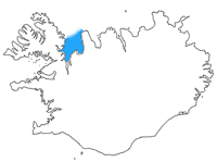
| Húnaflói | |
|---|---|
 Location of Húnaflói in Iceland Location of Húnaflói in Iceland | |
| Location | Northwestern Region and Westfjords |
| Coordinates | 65°50′N 20°50′W / 65.833°N 20.833°W / 65.833; -20.833 |
| Type | Bay |
| Etymology | húnn meaning 'polar bear cub' + flói meaning 'bay' |
| Ocean/sea sources | Iceland Sea |
| Max. length | 100 km (60 mi) |
| Max. width | 50 km (30 mi) |
| Surface area | 188.8 km (70 sq mi) |
| Islands | |
| Settlements | |
Húnaflói (Icelandic pronunciation: [ˈhuːnaˌflouːɪ], lit. 'Polar Bear Cub Bay') is a bay of the Iceland Sea in Northwestern Region and Westfjords, Iceland. It is situated between the village of Strandir on Vestfirðir peninsula to the west and the Skagaströnd of Skagi [is] peninsula to the east. Spanning 188.8 km (70 sq mi), it has a maximum width of about 50 km (30 mi) and length of 100 km (60 mi).
The Battle of the Gulf (Icelandic: Flóabardagi) was a naval battle on 25 June 1244 in Húnaflói, during the Age of the Sturlungs civil war. A detailed description of the battle can be found in Sturlunga saga.

Fauna
The bay has been proposed as a protected area for harbor seals.
References
- Svavar Sigmundsson (7 December 2016). "Hvaðan er forskeytið húna í Húnaflóa komið?". Vísindavefurinn (in Icelandic). Retrieved 5 August 2023.
- Williams, Richard S. (October 1995). "Icelandic-English Glossary of Selected Geoscience Terms (USGS Open-file Report 95-807)". United States Geological Survey. Retrieved 5 August 2023.
- "Náttúruminjaskrá: Húnaflói". Icelandic Institute of Natural History (in Icelandic and English). 3 December 2020. Retrieved 4 August 2023.
- "Leggja til að Rjúkandi og Hvalá verði friðuð" (in Icelandic). RÚV. 14 December 2020. Retrieved 5 April 2022.
This article about a fjord in Iceland is a stub. You can help Misplaced Pages by expanding it. |