You can help expand this article with text translated from the corresponding article in Vietnamese. (March 2009) Click for important translation instructions.
|
| Hưng Nguyên district Huyện Hưng Nguyên | |
|---|---|
| District | |
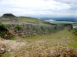
 A section of citadel on Lâm Thanh mountain, overlooking the front are Lam River and Hong Linh Mountain. The plot to the left is Truong Phu flagpole on the top of the mountain. A section of citadel on Lâm Thanh mountain, overlooking the front are Lam River and Hong Linh Mountain. The plot to the left is Truong Phu flagpole on the top of the mountain. | |
| Country | |
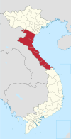
| Region | North Central Coast |
| Province | Nghệ An |
| Capital | Hưng Nguyên |
| Area | |
| • Total | 63 sq mi (162 km) |
| Population | |
| • Total | 120,720 |
| Time zone | UTC+07:00 (Indochina Time) |
Hưng Nguyên is a rural district of Nghệ An province in the North Central Coast region of Vietnam. As of 2003 the district had a population of 120,720. The district covers an area of 162 km². The district capital lies at Hưng Nguyên.
Administrative districts
Hung Nguyen district has 18 commune-level administrative units, including Hung Nguyen town (district capital) and 17 communes: Châu Nhân, Hưng Đạo, Hưng Lĩnh, Hưng Lợi, Hưng Mỹ, Hưng Nghĩa, Hưng Phúc, Hưng Tân, Hưng Tây, Hưng Thành, Hưng Thịnh, Hưng Thông, Hưng Trung, Hưng Yên Bắc, Hưng Yên Nam, Long Xá, Xuân Lam.
References
- ^ "Districts of Vietnam". Statoids. Retrieved March 20, 2009.
18°34′59″N 105°37′59″E / 18.583°N 105.633°E / 18.583; 105.633
| Districts of North Central Coast of Vietnam | ||
|---|---|---|
| Thanh Hóa province |  | |
| Nghệ An province | ||
| Hà Tĩnh province | ||
| Quảng Bình province |
| |
| Quảng Trị province | ||
| Huế |
| |
| denotes provincial seat. | ||
This article about a location in Nghệ An Province, Vietnam is a stub. You can help Misplaced Pages by expanding it. |