Human settlement in England
| Haltcliff Bridge | |
|---|---|
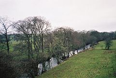
 River Caldew, north of Haltcliff Bridge River Caldew, north of Haltcliff Bridge | |
 | |
| OS grid reference | NY366365 |
| Civil parish | |
| District | |
| Shire county | |
| Region | |
| Country | England |
| Sovereign state | United Kingdom |
| Post town | WIGTON |
| Postcode district | CA7 |
| Dialling code | 016974 |
| Police | Cumbria |
| Fire | Cumbria |
| Ambulance | North West |
| UK Parliament | |
| 54°43′12″N 2°59′02″W / 54.720°N 2.984°W / 54.720; -2.984 | |
Haltcliff Bridge or Haltcliffe Bridge is a hamlet on the River Caldew, in the civil parish of Mungrisdale in the county of Cumbria, England. The spelling Haltcliffe is used by Mungrisdale parish council, by Royal Mail (e.g. for "The Mill" at CA7 8HX) and by English Heritage in their listing of Haltcliffe Hall, while Haltcliff appears on the Ordnance Survey map and in the 1870-1892 Imperial Gazetteer of England and Wales.
In the 2011 United Kingdom census the parish of Mungrisdale, comprising eight hamlets including Haltcliffe Bridge, had a population of 297.
See also
References
- "Mungrisdale Parish". www.mungrisdale.com. Retrieved 31 December 2021.
- Historic England. "Haltcliffe Hall and adjoining byre/barn (1138260)". National Heritage List for England. Retrieved 31 December 2021.
- "Descriptive Gazetteer Entry for Cadbeck". Vision of Britain. Retrieved 31 December 2021.
- "Mungrisdale Parish". www.mungrisdale.com. Retrieved 31 December 2021.
- UK Census (2011). "Local Area Report – Mungrisdale Parish (E04002557)". Nomis. Office for National Statistics. Retrieved 31 December 2021.
This Cumbria location article is a stub. You can help Misplaced Pages by expanding it. |