| Hanapēpē River | |
|---|---|
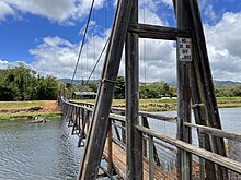
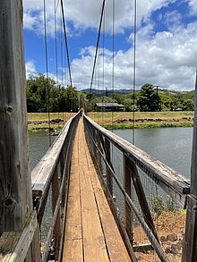
 Swinging bridge across the river in Hanapepe Swinging bridge across the river in Hanapepe | |
  | |
| Location | |
| Country | United States |
| State | Hawaii |
| Physical characteristics | |
| Source | Confluence of the Kō'ula River and Manuahi stream |
| Mouth | Pacific Ocean |
| • location | Hanapepe, Hawaii, Eleele, Hawaii |
| • coordinates | 21°54′15″N 159°35′29″W / 21.904223°N 159.591522°W / 21.904223; -159.591522 |
| • elevation | 0 m (0 ft) |
| Length | 24.2 km (15.0 mi) |
| Basin size | 27.7 sq mi (72 km) |
| Discharge | |
| • location | Below Manuahi stream |
| • average | 85.2 cu ft/s (2.41 m/s) |
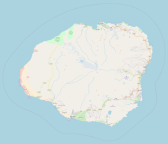
The Hanapepe River is a river on the Hawaiian island of Kauai. It begins at the confluence of the Kō'ula River with the Manuahi Stream and flows generally south, with a total length of 24.2 km (15.0 mi) to its mouth at Hanapepe and Eleele in the Pacific Ocean. The watershed covers an area of 27.7 square miles, draining roughly a twentieth of the island. The name Hanapepe translates to "crushed bay," which may refer to landslides in the area.

The river drains the fertile Hanapepe Valley, a region that was historically used for growing rice, taro, coffee, and sugarcane. During the late 19th and early 20th centuries, the valley attracted Chinese, Japanese, Korean, and Filipino immigrant workers, many of whom started their own farms or businesses. More recently, the Hanapepe Valley was used for filming parts of the 1993 Steven Spielberg film Jurassic Park.

Near its mouth in Hanapepe, the river passes under the Hanapepe Swinging Bridge. The footbridge was built in 1911 to provide Hanapepe residents with a way to cross the river, and was restored in 1992 after Hurricane Iniki. Considered a local tourist attraction, the bridge is popular with children due to its tendency to rock back and forth.


References
- "USGS Surface-Water Annual Statistics for the Nation". National Water Information System. United States Geological Survey. Retrieved November 17, 2019.
- U.S. Geological Survey. National Hydrography Dataset high-resolution flowline data. The National Map, accessed November 10, 2019
- "Hanapepe River, Kaua'i" (PDF). Hawaii Watershed Atlas. Retrieved November 14, 2019.
- Hanapepe River. "Hanapepe River Topo Map, Kauai County HI (Hanapepe Area)". Topozone.com. Retrieved 2018-01-22.
- Pukui, Mary Kawena. Place Names of Hawaii. University of Hawaii Press. ISBN 0-8248-0524-0.
- University of Hawaii. "Wehewehe". Double click on pēpē, and then doubleclick on pē.pē. University of Hawaii. Retrieved 15 November 2016.
- ^ "History". Hanapepe, Hawaii. Retrieved November 13, 2019.
- ^ "Hanapepe Valley Lookout". 'imi Tours. Retrieved November 13, 2019.
- Soboleski, Hank (March 17, 2013). "Minehaha, the rice-growing region of Hanapepe Valley". The Garden Island. Retrieved November 13, 2019.
- "Hanapepe Swinging Bridge". Kauai.com. Retrieved November 13, 2019.
External links
This article related to a river in Hawaii is a stub. You can help Misplaced Pages by expanding it. |