Town in New South Wales, Australia
| Hargraves New South Wales | |
|---|---|
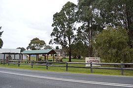
 A park in Hargraves A park in Hargraves | |
 | |
| Coordinates | 32°47′0″S 149°27′0″E / 32.78333°S 149.45000°E / -32.78333; 149.45000 |
| Population | 338 (2011 census) |
| Postcode(s) | 2850 |
| Location | |
| LGA(s) | Mid-Western Regional Council |
| State electorate(s) | Orange |
| Federal division(s) | Parkes |
Hargraves is a village in Central West New South Wales, Australia. It is 306 kilometres (190 mi) north west of the state capital of Sydney and 39 kilometres (24 mi) southwest of the town of Mudgee, New South Wales, Australia. At the 2011 census, Hargraves had a population of 338.
It lies within the traditional lands of the Wiradjuri people.
Initially known as Louisa Creek, it was renamed Hargraves after Edward Hargraves. It owes its origins to gold mining, which occurred there from the early 1850s.
See also
References
- ^ Australian Bureau of Statistics (31 October 2012). "Hargraves (SSC)". 2011 Census QuickStats. Retrieved 6 July 2014.

- "Tindale Tribes – Wiradjuri". archives.samuseum.sa.gov.au. Archived from the original on 17 March 2021. Retrieved 17 October 2020.
- http://hargravesnsw.com.au/web/ Archived 2 May 2013 at the Wayback Machine Hargraves
- "LOUISA CREEK. – The People's Advocate and New South Wales Vindicator (Sydney, NSW : 1848-1856) – 9 Oct 1852". Retrieved 17 October 2020 – via Trove.
External links
![]() Media related to Hargraves, New South Wales at Wikimedia Commons
Media related to Hargraves, New South Wales at Wikimedia Commons
This Central West geography article is a stub. You can help Misplaced Pages by expanding it. |