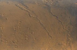
 Harmakhis Vallis is the rightmost channel pictured. The direction of water flow was toward the bottom of the image. Harmakhis Vallis is the rightmost channel pictured. The direction of water flow was toward the bottom of the image. | |
| Coordinates | 40°24′S 90°24′E / 40.4°S 90.4°E / -40.4; 90.4 |
|---|---|
| Naming | Ancient Egyptian word for "Mars" |
Harmakhis Vallis is a valley near Hellas Planitia, Mars. It has been identified as an outflow channel, the site of catastrophic floods of water during Mars' past.
Gullies are also common on the wall of Harmakhis Vallis, as seen the image below. Some authors have suggested these structures indicate geologically recent flow of small quantities of water across the surface.
See also
References
- Heldmann, J. and M. Mellon. Observations of Martian gullies and constraints on potential formation mechanisms. 2004. Icarus. 168: 285-304.
- Further reading
- Bleamaster, L, Crown, D (2004). Morphologic Development of Harmakhis Vallis, Mars (PDF). Lunar and Planetary Science Conference.
{{cite conference}}: CS1 maint: multiple names: authors list (link) - Price, K (1992). Geologic Mapping of Part of Harmakhis Vallis Region, Mars: Evidence of Multiple Drainage Events. Lunar and Planetary Science Conference. Bibcode:1992LPI....23.1107P.
External links
Portal:
This article about geology, geography or other features of the planet Mars or its moons is a stub. You can help Misplaced Pages by expanding it. |
