| |
|---|---|
| Town/City | |
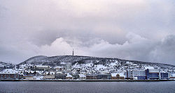
 View of the town View of the town | |
  | |
| Coordinates: 68°48′04″N 16°32′39″E / 68.80112°N 16.54414°E / 68.80112; 16.54414 | |
| Country | Norway |
| Region | Northern Norway |
| County | Troms |
| District | Central Hålogaland |
| Municipality | Harstad Municipality |
| Established as | |
| Town (By) | 1904 |
| Area | |
| • Total | 11.45 km (4.42 sq mi) |
| Elevation | 3 m (10 ft) |
| Population | |
| • Total | 21,289 |
| • Density | 1,858/km (4,810/sq mi) |
| Time zone | UTC+01:00 (CET) |
| • Summer (DST) | UTC+02:00 (CEST) |
| Post Code | 9405 Harstad |
| Former municipality in Troms, Norway | |
| Former municipality | |
| Harstad ladested | |
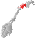
 Troms within Norway Troms within Norway | |
 Harstad within Troms Harstad within Troms | |
| Country | Norway |
| County | Troms |
| District | Central Hålogaland |
| Established | 1904 |
| • Preceded by | Trondenes Municipality |
| Disestablished | 1 Jan 1964 |
| • Succeeded by | Harstad Municipality |
| Administrative centre | Harstad |
| Area | |
| • Total | 0.7 km (0.3 sq mi) |
| • Rank | #679 in Norway |
| Population | |
| • Total | 3,860 |
| • Rank | #231 in Norway |
| • Density | 5,514/km (14,280/sq mi) |
| • Change (10 years) | |
| ISO 3166 code | NO-1901 |
| Data from Statistics Norway | |
Harstad (Norwegian, pronounced [hɐ̞̂ɻ.ʃt̠ɐ̞] ) or Hárstták (Northern Sami) is a city in Harstad Municipality in Troms county, Norway. The city is also the administrative centre of Harstad Municipality. The 11.46-square-kilometre (2,830-acre) city has a population (2023) of 21,289 (31,404 in the Urban area) and a population density of 1,858 inhabitants per square kilometre (4,810/sq mi). It is the second-largest town in Troms county, after the city of Tromsø, and it is the largest town in Central Hålogaland.
The town is located on the northeastern part of the large island of Hinnøya, along the Vågsfjorden. The city is made up of several areas (bydeler) including Gansås, Grønnebakkan, Kanebogen, Medkila, Sama, Seljestad, Stangnes, and Trondenes and more. There are two churches of the Church of Norway in the town: Harstad Church and Kanebogen Church. The historic Trondenes Church lies on the north edge of the town, near the Trondenes Fort.
 Winter view
History
On 1 January 1904, the village of Harstad was granted town privileges as a ladested. On the same date, the new town was separated from the Trondenes Municipality to become a separate town-municipality of its own. Initially, the town of Harstad had 1,246 residents. The town of Harstad existed as its own municipality between 1 January 1904 until 31 December 1963.
During the 1960s, there were many municipal mergers across Norway due to the work of the Schei Committee. On 1 January 1964, the town of Harstad (population: 3,808) was merged with Trondenes Municipality (population: 6,567) to the north and Sandtorg Municipality (population: 7,512) to the south, forming a new, much larger Harstad Municipality.
Name
The town (and municipality) is named after the old Harstad farm (Old Norse: Harðarstaðir), since the town is built where the farm once was located. The first element is (probably) the genitive case of the male name Hǫrðr. The last element is staðir which means "homestead" or "farm". On 6 February 2017, the municipality of Harstad adopted a co-equal Sami language name for the municipality: Hárstták. The Sami language name spelling changes depending on how it is used. It is called Hárstták when it is spelled alone, but it is Hársttáid suohkan when using the Sami language equivalent to "Harstad municipality".
Government
Main article: Harstad Municipality § GovernmentThe city of Harstad is part of Harstad Municipality. The urban city area itself is not self-governing, but rather the mayor and municipal council for the whole municipality oversees the city and entire municipality. From 1904 until 1963, the city and the municipality were coterminous, but since 1964, the municipality has been much more than just the city.
Media gallery
-
 View point
-
 Northern part of town
-
 Town centre
-
 Harstad in winter
-
 View from Gangsåstoppen
-
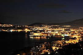
 Nocturnal view
-
Harstad Church
 Panorama from westerly hill
See also
References
- ^ In the Norwegian language, the word by can be translated as "town" or "city".
- ^ Statistisk sentralbyrå (2023-12-23). "Urban settlements. Population and area, by municipality".
- "Harstad, Harstad (Troms)". yr.no. Retrieved 2018-09-01.
- Bolstad, Erik; Thorsnæs, Geir, eds. (2023-01-26). "Kommunenummer". Store norske leksikon (in Norwegian). Kunnskapsforlaget.
- "Informasjon om stadnamn". Norgeskart (in Norwegian). Kartverket. Retrieved 2024-07-28.
- ^ "Stadnamn og rettskriving" (in Norwegian). Kartverket. Retrieved 2023-11-19.
- Thorsnæs, Geir, ed. (2018-02-21). "Harstad". Store norske leksikon (in Norwegian). Kunnskapsforlaget. Retrieved 2018-09-01.
- Jukvam, Dag (1999). "Historisk oversikt over endringer i kommune- og fylkesinndelingen" (PDF) (in Norwegian). Statistisk sentralbyrå.
- ^ Rygh, Oluf (1911). Norske gaardnavne: Troms amt (in Norwegian) (17 ed.). Kristiania, Norge: W. C. Fabritius & sønners bogtrikkeri. p. 21.
- "Harstad fikk samisk navn". NRK Nord-Norge (in Norwegian). 2017-02-06.
 Definitions from Wiktionary
 Media from Commons
 Travel guides from Wikivoyage
 Data from Wikidata
| Troms county, Norway | |||||||
|---|---|---|---|---|---|---|---|
| |||||||
 | Towns and cities | ||||||
| Municipalities |
| ||||||
| |||||||
| Most populous urban areas of Norway | ||
|---|---|---|
| As of 1 January 2023, according to Statistics Norway | ||
|  | |